Rafaela geodata
Rafaela (Santa Fe) is a seat of a second-order administrative division; located in Argentina in America/Argentina/Cordoba (GMT-3) time zone. With population of 88,713 people, there are 45 cities with bigger population in this country. Compared to other cities in Argentina, 57.4% of cities are located further ↓South; 57.9% of cities are located further ←West and 61.7% of cities have higher elevation than Rafaela. Note1


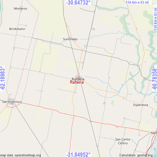
Rafaela GPS coordinates[2]
31° 15' 1.188" South, 61° 29' 12.12" West
| Map corner | latitude | longitude |
|---|---|---|
| Upper-left | -30.64732°, | -62.18983° |
| Center: | -31.25033°, | -61.4867° |
| Lower-right: | -31.84952°, | -60.78358° |
| Map W x H: | 133.7×133.7 km | = 83.1×83.1mi |
| max Lat: | -21.94467° ⇑42.6% North |
| Rafaela: | -31.25033° |
| min Lat: | ⇓57.4% South -54.81084° |
| min Long | Rafaela | max Long |
| -72.88605° | -61.4867° | -53.64581° |
| W 57.9%⇐ | ⇒42.1% E |
Elevation
Elevation of Rafaela is 103 m = 338 ft, and this is 246.3 m = 808 ft below average elevation for this country.
| Max E: |
4040 m = 13255 ft | 61.7% |
| Avg. | 349.3 m = 1146 ft | |
| Rafaela | 103 m = 338 ft | |
Min E: |
-2 m = -7 ft | 38.3% |
See also: Rafaela elevation on elevation.city.
Geographical zone
Rafaela is located in South temperate zone (between Tropic of Capricorn and the Antarctic Circle). Distance of this Southern Tropic circle is 868.8 km =539.8 mi to North.| Distance of | km | miles | from Rafaela |
|---|---|---|---|
| Equator | 3474.7 | 2159.1 | to North |
| Tropic Capricorn | 868.8 | 539.8 | to North |
| Antarctic Circle | 3926.5 | 2439.8 | to South |
| South Pole | 6532.4 | 4059 | to South |


Nearby cities:
15 places around Rafaela: (largest is in red/bold)
• Bella Italia
8 km =5 mi,  115°
115°
• Brinkmann
67.7 km =42.1 mi,  309°
309°
• Devoto
79.7 km =49.5 mi,  257°
257°
• Esperanza
57.1 km =35.5 mi,  112°
112°
• Laguna Paiva
78.9 km =49 mi,  94°
94°
• Morteros
77.3 km =48 mi,  320°
320°
• Porteña
61.1 km =38 mi,  295°
295°
• Recreo
76.4 km =47.5 mi, 110°
• San Carlos Centro
65 km =40.4 mi,  144°
144°
• San Francisco
59.9 km =37.2 mi,  250°
250°
• San Jorge
80 km =49.7 mi,  206°
206°
• Santa Fe
86.1 km =53.5 mi, 120°
• Santo Tomé
82.4 km =51.2 mi, 123°
• Sastre
66 km =41 mi, 209°
• Sunchales
34.8 km =21.6 mi,  348°
348°
Sources, notices
• [Note1] Compared only with cities in Argentina existing in our database
• [Src1] Map data: © OpenStreetMap contributors (CC-BY-SA)
• [Src2] Other city data from geonames.org with taken over terms of usage.
• [Src3] Geographical zone / Annual Mean Temperature by Robert A. Rohde @ Wikipedia
