Salsacate geodata
Salsacate (Cordoba) is a seat of a second-order administrative division; located in Argentina in America/Argentina/Cordoba (GMT-3) time zone. With population of 1,205 people, there are 737 cities with bigger population in this country. Compared to other cities in Argentina, 56.6% of cities are located further ↓South; 73.3% of cities are located further →East and 91.3% of cities have lower elevation than Salsacate. Note1


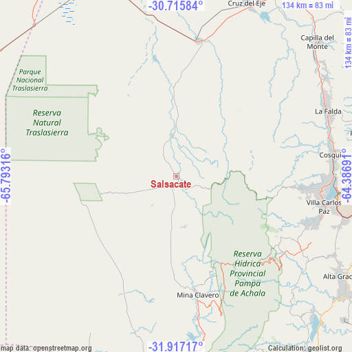
Salsacate GPS coordinates[2]
31° 19' 6.312" South, 65° 5' 24.108" West
| Map corner | latitude | longitude |
|---|---|---|
| Upper-left | -30.71584°, | -65.79316° |
| Center: | -31.31842°, | -65.09003° |
| Lower-right: | -31.91717°, | -64.38691° |
| Map W x H: | 133.6×133.6 km | = 83×83mi |
| max Lat: | -21.94467° ⇑43.4% North |
| Salsacate: | -31.31842° |
| min Lat: | ⇓56.6% South -54.81084° |
| min Long | Salsacate | max Long |
| -72.88605° | -65.09003° | -53.64581° |
| W 26.7%⇐ | ⇒73.3% E |
Elevation
Elevation of Salsacate is 927 m = 3041 ft, and this is 577.7 m = 1895 ft above average elevation for this country.
| Max E: |
4040 m = 13255 ft | 8.7% |
| Salsacate | 927 m 3041 ft | |
| Avg. | 349.3 m = 1146 ft | |
Min E: |
-2 m = -7 ft | 91.3% |
See also: Argentina elevation on elevation.city.
Geographical zone
Salsacate is located in South temperate zone (between Tropic of Capricorn and the Antarctic Circle). Distance of this Southern Tropic circle is 876.4 km =544.6 mi to North.| Distance of | km | miles | from Salsacate |
|---|---|---|---|
| Equator | 3482.3 | 2163.8 | to North |
| Tropic Capricorn | 876.4 | 544.6 | to North |
| Antarctic Circle | 3918.9 | 2435.1 | to South |
| South Pole | 6524.8 | 4054.3 | to South |


Nearby cities:
15 places around Salsacate: (largest is in red/bold)
• Cosquín
59.9 km =37.2 mi,  82°
82°
• Cuesta Blanca
52.6 km =32.7 mi,  110°
110°
• Huerta Grande
63.1 km =39.2 mi,  64°
64°
• La Cumbre
68.1 km =42.3 mi, 56°
• La Falda
62.5 km =38.8 mi,  65°
65°
• Los Cocos
71 km =44.1 mi,  51°
51°
• Mina Clavero
45.5 km =28.3 mi,  169°
169°
• San Carlos
15.7 km =9.8 mi,  355°
355°
• Valle Hermoso
62.1 km =38.6 mi, 68°
• Villa Carlos Paz
57.4 km =35.7 mi,  101°
101°
• Villa Cura Brochero
43.6 km =27.1 mi, 170°
• Villa Dolores
70.4 km =43.7 mi,  187°
187°
• Villa Giardino
65.8 km =40.9 mi, 61°
• Villa Las Rosas
70.3 km =43.7 mi,  177°
177°
• Villa de Soto
52.2 km =32.4 mi,  9°
9°
Sources, notices
• [Note1] Compared only with cities in Argentina existing in our database
• [Src1] Map data: © OpenStreetMap contributors (CC-BY-SA)
• [Src2] Other city data from geonames.org with taken over terms of usage.
• [Src3] Geographical zone / Annual Mean Temperature by Robert A. Rohde @ Wikipedia
