Villa Dolores geodata
Villa Dolores (Cordoba) is a populated place; located in Argentina in America/Argentina/Cordoba (GMT-3) time zone. With population of 28,009 people, there are 145 cities with bigger population in this country. Compared to other cities in Argentina, 51.1% of cities are located further ↑North; 74.1% of cities are located further →East and 78.3% of cities have lower elevation than Villa Dolores. Note1


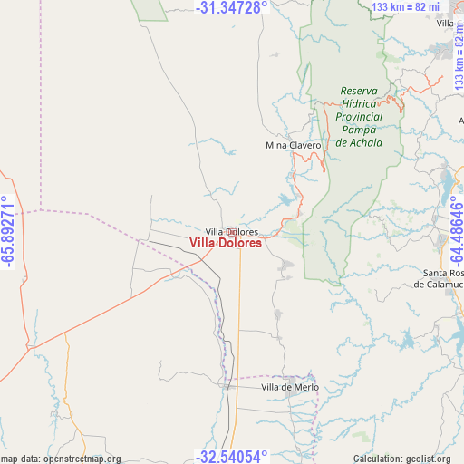
Villa Dolores GPS coordinates[2]
31° 56' 45.06" South, 65° 11' 22.488" West
| Map corner | latitude | longitude |
|---|---|---|
| Upper-left | -31.34728°, | -65.89271° |
| Center: | -31.94585°, | -65.18958° |
| Lower-right: | -32.54054°, | -64.48646° |
| Map W x H: | 132.7×132.7 km | = 82.5×82.5mi |
| max Lat: | -21.94467° ⇑51.1% North |
| Villa Dolores: | -31.94585° |
| min Lat: | ⇓48.9% South -54.81084° |
| min Long | Villa Dolores | max Long |
| -72.88605° | -65.18958° | -53.64581° |
| W 25.9%⇐ | ⇒74.1% E |
Elevation
Elevation of Villa Dolores is 523 m = 1716 ft, and this is 173.7 m = 570 ft above average elevation for this country.
| Max E: |
4040 m = 13255 ft | 21.7% |
| Villa Dolores | 523 m 1716 ft | |
| Avg. | 349.3 m = 1146 ft | |
Min E: |
-2 m = -7 ft | 78.3% |
See also: Argentina elevation on elevation.city.
Geographical zone
Villa Dolores is located in South temperate zone (between Tropic of Capricorn and the Antarctic Circle). Distance of this Southern Tropic circle is 946.1 km =587.9 mi to North.| Distance of | km | miles | from Villa Dolores |
|---|---|---|---|
| Equator | 3552 | 2207.1 | to North |
| Tropic Capricorn | 946.1 | 587.9 | to North |
| Antarctic Circle | 3849.1 | 2391.7 | to South |
| South Pole | 6455 | 4010.9 | to South |


Nearby cities:
15 places around Villa Dolores: (largest is in red/bold)
• Candelaria
61.2 km =38 mi,  257°
257°
• Concarán
68.5 km =42.6 mi,  184°
184°
• La Cumbrecita
39.6 km =24.6 mi,  82°
82°
• Libertador General San Martín
69 km =42.9 mi,  221°
221°
• Merlo
47.1 km =29.3 mi,  159°
159°
• Mina Clavero
30.4 km =18.9 mi,  34°
34°
• Salsacate
70.4 km =43.7 mi,  7°
7°
• Santa Rosa de Calamuchita
63.1 km =39.2 mi,  102°
102°
• Santa Rosa del Conlara
44.2 km =27.5 mi, 181°
• Villa Berna
43.3 km =26.9 mi,  85°
85°
• Villa Cura Brochero
31.2 km =19.4 mi, 31°
• Villa General Belgrano
59.9 km =37.2 mi, 93°
• Villa Las Rosas
12.8 km =8 mi, 92°
• Villa Rumipal
72.1 km =44.8 mi,  111°
111°
• Villa del Dique
73.8 km =45.9 mi, 110°
Sources, notices
• [Note1] Compared only with cities in Argentina existing in our database
• [Src1] Map data: © OpenStreetMap contributors (CC-BY-SA)
• [Src2] Other city data from geonames.org with taken over terms of usage.
• [Src3] Geographical zone / Annual Mean Temperature by Robert A. Rohde @ Wikipedia
