San Carlos de Bariloche geodata
San Carlos de Bariloche (Rio Negro) is a seat of a third-order administrative division; located in Argentina in America/Argentina/Salta (GMT-3) time zone. With population of 95,394 people, there are 40 cities with bigger population in this country. Compared to other cities in Argentina, 95.1% of cities are located further ↑North; 98.6% of cities are located further →East and 89.2% of cities have lower elevation than San Carlos de Bariloche. Note1
Administrative division(s):
- Level 1: Rio Negro
- Level 2: Departamento de Bariloche
- Level 3: San Carlos de Bariloche
Current local time in San Carlos de Bariloche:
06:39 AM, SaturdayDifference from your time zone: hours


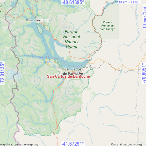
San Carlos de Bariloche GPS coordinates[2]
41° 8' 44.052" South, 71° 18' 29.592" West
| Map corner | latitude | longitude |
|---|---|---|
| Upper-left | -40.61395°, | -72.01135° |
| Center: | -41.14557°, | -71.30822° |
| Lower-right: | -41.67291°, | -70.6051° |
| Map W x H: | 117.7×117.7 km | = 73.1×73.1mi |
| max Lat: | -21.94467° ⇑95.1% North |
| San Carlos de Bariloche: | -41.14557° |
| min Lat: | ⇓4.9% South -54.81084° |
| min Long | San Carlos de B | max Long |
| -72.88605° | -71.30822° | -53.64581° |
| W 1.4%⇐ | ⇒98.6% E |
Elevation
Elevation of San Carlos de Bariloche is 839 m = 2753 ft, and this is 489.7 m = 1607 ft above average elevation for this country.
| Max E: |
4040 m = 13255 ft | 10.8% |
| San Carlos de Bariloche | 839 m 2753 ft | |
| Avg. | 349.3 m = 1146 ft | |
Min E: |
-2 m = -7 ft | 89.2% |
See also: San Carlos de Bariloche elevation on elevation.city.
Geographical zone
San Carlos de Bariloche is located in South temperate zone (between Tropic of Capricorn and the Antarctic Circle). Distance of this Southern Tropic circle is 1969 km =1223.5 mi to North.| Distance of | km | miles | from San Carlos de Bariloche |
|---|---|---|---|
| Equator | 4575 | 2842.8 | to North |
| Tropic Capricorn | 1969 | 1223.5 | to North |
| Antarctic Circle | 2826.2 | 1756.1 | to South |
| South Pole | 5432.1 | 3375.3 | to South |


Nearby cities:
15 places around San Carlos de Bariloche: (largest is in red/bold)
• Comallo
88.1 km =54.7 mi,  81°
81°
• El Bolsón
92.5 km =57.5 mi,  191°
191°
• El Maitén
101.2 km =62.9 mi,  173°
173°
• Esquel
196.4 km =122 mi,  180°
180°
• Hoyo de Epuyén
104.3 km =64.8 mi, 189°
• Ingeniero Jacobacci
148.4 km =92.2 mi,  97°
97°
• Junín de los Andes
134.4 km =83.5 mi,  8°
8°
• Lago Puelo
105.3 km =65.4 mi, 193°
• Las Coloradas
186.9 km =116.1 mi,  18°
18°
• Leleque
142.2 km =88.4 mi, 171°
• Piedra del Águila
160.5 km =99.7 mi,  40°
40°
• Pilcaniyeu
49.2 km =30.6 mi,  87°
87°
• San Martín de los Andes
109.9 km =68.3 mi,  358°
358°
• Villa La Angostura
51.3 km =31.9 mi,  326°
326°
• Ñorquinco
85.4 km =53.1 mi,  156°
156°
In other languages:
- In France: Bariloche
- In German: Bariloche
- In Russian: Сан Карлос де Барилоче
- In Chinese: 圣卡洛斯-德巴里洛切
Sources, notices
• [Note1] Compared only with cities in Argentina existing in our database
• [Src1] Map data: © OpenStreetMap contributors (CC-BY-SA)
• [Src2] Other city data from geonames.org with taken over terms of usage.
• [Src3] Geographical zone / Annual Mean Temperature by Robert A. Rohde @ Wikipedia
