Monteros geodata
Monteros (Tucuman) is a seat of a second-order administrative division; located in Argentina in America/Argentina/Tucuman (GMT-3) time zone. With population of 23,771 people, there are 169 cities with bigger population in this country. Compared to other cities in Argentina, 84.7% of cities are located further ↓South; 77.9% of cities are located further →East and 71.2% of cities have lower elevation than Monteros. Note1


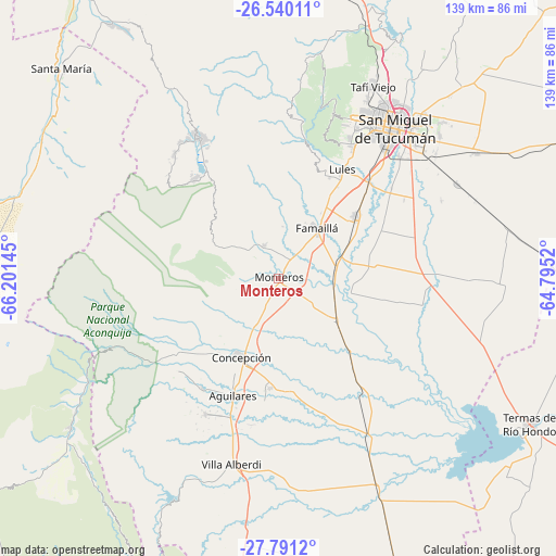
Monteros GPS coordinates[2]
27° 10' 2.676" South, 65° 29' 53.952" West
| Map corner | latitude | longitude |
|---|---|---|
| Upper-left | -26.54011°, | -66.20145° |
| Center: | -27.16741°, | -65.49832° |
| Lower-right: | -27.7912°, | -64.7952° |
| Map W x H: | 139.1×139.1 km | = 86.4×86.4mi |
| max Lat: | -21.94467° ⇑15.3% North |
| Monteros: | -27.16741° |
| min Lat: | ⇓84.7% South -54.81084° |
| min Long | Monteros | max Long |
| -72.88605° | -65.49832° | -53.64581° |
| W 22.1%⇐ | ⇒77.9% E |
Elevation
Elevation of Monteros is 360 m = 1181 ft, and this is 10.7 m = 35 ft above average elevation for this country.
| Max E: |
4040 m = 13255 ft | 28.8% |
| Monteros | 360 m 1181 ft | |
| Avg. | 349.3 m = 1146 ft | |
Min E: |
-2 m = -7 ft | 71.2% |
See also: Argentina elevation on elevation.city.
Geographical zone
Monteros is located in South temperate zone (between Tropic of Capricorn and the Antarctic Circle). Distance of this Southern Tropic circle is 414.8 km =257.7 mi to North.| Distance of | km | miles | from Monteros |
|---|---|---|---|
| Equator | 3020.7 | 1877 | to North |
| Tropic Capricorn | 414.8 | 257.7 | to North |
| Antarctic Circle | 4380.4 | 2721.9 | to South |
| South Pole | 6986.3 | 4341.1 | to South |


Nearby cities:
15 places around Monteros: (largest is in red/bold)
• Aguilares
31.8 km =19.8 mi,  201°
201°
• Alderetes
53.2 km =33.1 mi,  42°
42°
• Banda del Río Salí
49.6 km =30.8 mi, 41°
• Bella Vista
24.4 km =15.2 mi,  52°
52°
• Concepción
21.6 km =13.4 mi,  206°
206°
• Famaillá
15.7 km =9.8 mi, 36°
• Graneros
53.9 km =33.5 mi,  173°
173°
• La Cocha
67.5 km =41.9 mi,  187°
187°
• San Isidro de Lules
31 km =19.3 mi,  30°
30°
• San Miguel de Tucumán
46.9 km =29.1 mi, 35°
• Simoca
17.6 km =10.9 mi,  127°
127°
• Tafí Viejo
53.9 km =33.5 mi, 26°
• Tafí del Valle
40.8 km =25.4 mi,  329°
329°
• Termas de Río Hondo
72.8 km =45.2 mi,  119°
119°
• Yerba Buena
43 km =26.7 mi,  24°
24°
Sources, notices
• [Note1] Compared only with cities in Argentina existing in our database
• [Src1] Map data: © OpenStreetMap contributors (CC-BY-SA)
• [Src2] Other city data from geonames.org with taken over terms of usage.
• [Src3] Geographical zone / Annual Mean Temperature by Robert A. Rohde @ Wikipedia
