Aguilares geodata
Aguilares (Tucuman) is a seat of a second-order administrative division; located in Argentina in America/Argentina/Tucuman (GMT-3) time zone. With population of 32,494 people, there are 125 cities with bigger population in this country. Compared to other cities in Argentina, 81.7% of cities are located further ↓South; 79% of cities are located further →East and 72.2% of cities have lower elevation than Aguilares. Note1


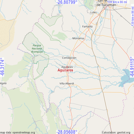
Aguilares GPS coordinates[2]
27° 26' 1.68" South, 65° 36' 51.372" West
| Map corner | latitude | longitude |
|---|---|---|
| Upper-left | -26.80799°, | -66.3174° |
| Center: | -27.4338°, | -65.61427° |
| Lower-right: | -28.05608°, | -64.91115° |
| Map W x H: | 138.8×138.8 km | = 86.2×86.2mi |
| max Lat: | -21.94467° ⇑18.3% North |
| Aguilares: | -27.4338° |
| min Lat: | ⇓81.7% South -54.81084° |
| min Long | Aguilares | max Long |
| -72.88605° | -65.61427° | -53.64581° |
| W 21%⇐ | ⇒79% E |
Elevation
Elevation of Aguilares is 375 m = 1230 ft, and this is 25.7 m = 84 ft above average elevation for this country.
| Max E: |
4040 m = 13255 ft | 27.8% |
| Aguilares | 375 m 1230 ft | |
| Avg. | 349.3 m = 1146 ft | |
Min E: |
-2 m = -7 ft | 72.2% |
See also: Argentina elevation on elevation.city.
Geographical zone
Aguilares is located in South temperate zone (between Tropic of Capricorn and the Antarctic Circle). Distance of this Southern Tropic circle is 444.4 km =276.1 mi to North.| Distance of | km | miles | from Aguilares |
|---|---|---|---|
| Equator | 3050.4 | 1895.4 | to North |
| Tropic Capricorn | 444.4 | 276.1 | to North |
| Antarctic Circle | 4350.8 | 2703.5 | to South |
| South Pole | 6956.7 | 4322.7 | to South |


Nearby cities:
15 places around Aguilares: (largest is in red/bold)
• Andalgalá
71.2 km =44.2 mi,  256°
256°
• Bella Vista
54.1 km =33.6 mi,  34°
34°
• Concepción
10.4 km =6.5 mi,  9°
9°
• Famaillá
47.1 km =29.3 mi, 26°
• Graneros
29.6 km =18.4 mi,  144°
144°
• La Cocha
37.4 km =23.2 mi,  175°
175°
• Los Altos
69.3 km =43.1 mi,  170°
170°
• Los Varela
60.7 km =37.7 mi,  204°
204°
• Monteros
31.8 km =19.8 mi,  21°
21°
• San Antonio
64.7 km =40.2 mi,  188°
188°
• San Isidro de Lules
62.5 km =38.8 mi, 25°
• San Pedro
72.7 km =45.2 mi, 142°
• Simoca
31.8 km =19.8 mi,  53°
53°
• Tafí del Valle
65.3 km =40.6 mi,  351°
351°
• Yerba Buena
74.7 km =46.4 mi, 23°
Sources, notices
• [Note1] Compared only with cities in Argentina existing in our database
• [Src1] Map data: © OpenStreetMap contributors (CC-BY-SA)
• [Src2] Other city data from geonames.org with taken over terms of usage.
• [Src3] Geographical zone / Annual Mean Temperature by Robert A. Rohde @ Wikipedia
