Yerba Buena geodata
Yerba Buena (Tucuman) is a seat of a second-order administrative division; located in Argentina in America/Argentina/Tucuman (GMT-3) time zone. With population of 50,783 people, there are 86 cities with bigger population in this country. Compared to other cities in Argentina, 88% of cities are located further ↓South; 75.6% of cities are located further →East and 77.9% of cities have lower elevation than Yerba Buena. Note1


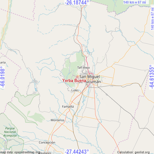
Yerba Buena GPS coordinates[2]
26° 49' 0.012" South, 65° 19' 0.012" West
| Map corner | latitude | longitude |
|---|---|---|
| Upper-left | -26.18744°, | -66.0198° |
| Center: | -26.81667°, | -65.31667° |
| Lower-right: | -27.44243°, | -64.61355° |
| Map W x H: | 139.5×139.5 km | = 86.7×86.7mi |
| max Lat: | -21.94467° ⇑12% North |
| Yerba Buena: | -26.81667° |
| min Lat: | ⇓88% South -54.81084° |
| min Long | Yerba Buena | max Long |
| -72.88605° | -65.31667° | -53.64581° |
| W 24.4%⇐ | ⇒75.6% E |
Elevation
Elevation of Yerba Buena is 515 m = 1690 ft, and this is 165.7 m = 544 ft above average elevation for this country.
| Max E: |
4040 m = 13255 ft | 22.1% |
| Yerba Buena | 515 m 1690 ft | |
| Avg. | 349.3 m = 1146 ft | |
Min E: |
-2 m = -7 ft | 77.9% |
See also: Yerba Buena elevation on elevation.city.
Geographical zone
Yerba Buena is located in South temperate zone (between Tropic of Capricorn and the Antarctic Circle). Distance of this Southern Tropic circle is 375.8 km =233.5 mi to North.| Distance of | km | miles | from Yerba Buena |
|---|---|---|---|
| Equator | 2981.7 | 1852.7 | to North |
| Tropic Capricorn | 375.8 | 233.5 | to North |
| Antarctic Circle | 4419.4 | 2746.1 | to South |
| South Pole | 7025.3 | 4365.3 | to South |


Nearby cities:
15 places around Yerba Buena: (largest is in red/bold)
• Aguilares
74.7 km =46.4 mi,  203°
203°
• Alderetes
18.2 km =11.3 mi,  90°
90°
• Banda del Río Salí
15 km =9.3 mi,  97°
97°
• Bella Vista
24.2 km =15 mi,  176°
176°
• Burruyacú
67.1 km =41.7 mi,  58°
58°
• Concepción
64.6 km =40.1 mi,  205°
205°
• Famaillá
27.8 km =17.3 mi, 198°
• Monteros
43 km =26.7 mi, 204°
• San Isidro de Lules
12.5 km =7.8 mi,  190°
190°
• San Miguel de Tucumán
9.4 km =5.8 mi, 95°
• Santa María
73.8 km =45.9 mi,  280°
280°
• Simoca
49.8 km =30.9 mi, 184°
• Tafí Viejo
11 km =6.8 mi,  31°
31°
• Tafí del Valle
39.2 km =24.4 mi,  264°
264°
• Trancas
65.2 km =40.5 mi,  3°
3°
Sources, notices
• [Note1] Compared only with cities in Argentina existing in our database
• [Src1] Map data: © OpenStreetMap contributors (CC-BY-SA)
• [Src2] Other city data from geonames.org with taken over terms of usage.
• [Src3] Geographical zone / Annual Mean Temperature by Robert A. Rohde @ Wikipedia
