Famaillá geodata
Famaillá (Tucuman) is a seat of a second-order administrative division; located in Argentina in America/Argentina/Tucuman (GMT-3) time zone. With population of 30,951 people, there are 135 cities with bigger population in this country. Compared to other cities in Argentina, 85.7% of cities are located further ↓South; 76.9% of cities are located further →East and 71.8% of cities have lower elevation than Famaillá. Note1


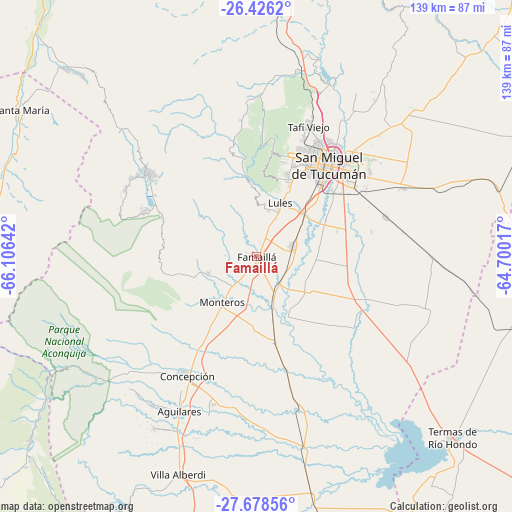
Famaillá GPS coordinates[2]
27° 3' 14.868" South, 65° 24' 11.844" West
| Map corner | latitude | longitude |
|---|---|---|
| Upper-left | -26.4262°, | -66.10642° |
| Center: | -27.05413°, | -65.40329° |
| Lower-right: | -27.67856°, | -64.70017° |
| Map W x H: | 139.2×139.3 km | = 86.5×86.6mi |
| max Lat: | -21.94467° ⇑14.3% North |
| Famaillá: | -27.05413° |
| min Lat: | ⇓85.7% South -54.81084° |
| min Long | Famaillá | max Long |
| -72.88605° | -65.40329° | -53.64581° |
| W 23.1%⇐ | ⇒76.9% E |
Elevation
Elevation of Famaillá is 368 m = 1207 ft, and this is 18.7 m = 61 ft above average elevation for this country.
| Max E: |
4040 m = 13255 ft | 28.2% |
| Famaillá | 368 m 1207 ft | |
| Avg. | 349.3 m = 1146 ft | |
Min E: |
-2 m = -7 ft | 71.8% |
See also: Argentina elevation on elevation.city.
Geographical zone
Famaillá is located in South temperate zone (between Tropic of Capricorn and the Antarctic Circle). Distance of this Southern Tropic circle is 402.2 km =249.9 mi to North.| Distance of | km | miles | from Famaillá |
|---|---|---|---|
| Equator | 3008.1 | 1869.1 | to North |
| Tropic Capricorn | 402.2 | 249.9 | to North |
| Antarctic Circle | 4393 | 2729.7 | to South |
| South Pole | 6998.9 | 4348.9 | to South |


Nearby cities:
15 places around Famaillá: (largest is in red/bold)
• Aguilares
47.1 km =29.3 mi,  206°
206°
• Alderetes
37.6 km =23.4 mi,  45°
45°
• Banda del Río Salí
34 km =21.1 mi,  43°
43°
• Bella Vista
10.3 km =6.4 mi,  77°
77°
• Concepción
37.2 km =23.1 mi, 210°
• Graneros
66.3 km =41.2 mi,  182°
182°
• Monteros
15.7 km =9.8 mi,  216°
216°
• San Isidro de Lules
15.4 km =9.6 mi,  24°
24°
• San Miguel de Tucumán
31.2 km =19.4 mi, 35°
• Santa María
75.3 km =46.8 mi,  301°
301°
• Simoca
23.7 km =14.7 mi,  168°
168°
• Tafí Viejo
38.6 km =24 mi, 21°
• Tafí del Valle
37.7 km =23.4 mi,  306°
306°
• Termas de Río Hondo
72.6 km =45.1 mi,  132°
132°
• Yerba Buena
27.8 km =17.3 mi, 18°
Sources, notices
• [Note1] Compared only with cities in Argentina existing in our database
• [Src1] Map data: © OpenStreetMap contributors (CC-BY-SA)
• [Src2] Other city data from geonames.org with taken over terms of usage.
• [Src3] Geographical zone / Annual Mean Temperature by Robert A. Rohde @ Wikipedia
