Monte Cristo geodata
Monte Cristo (Cordoba) is a populated place; located in Argentina in America/Argentina/Cordoba (GMT-3) time zone. With population of 6,914 people, there are 367 cities with bigger population in this country. Compared to other cities in Argentina, 56.2% of cities are located further ↓South; 60.5% of cities are located further →East and 70.4% of cities have lower elevation than Monte Cristo. Note1


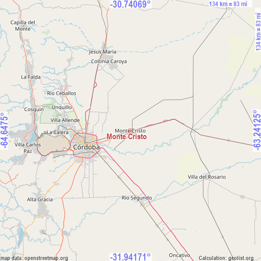
Monte Cristo GPS coordinates[2]
31° 20' 35.232" South, 63° 56' 39.732" West
| Map corner | latitude | longitude |
|---|---|---|
| Upper-left | -30.74069°, | -64.6475° |
| Center: | -31.34312°, | -63.94437° |
| Lower-right: | -31.94171°, | -63.24125° |
| Map W x H: | 133.5×133.5 km | = 83×83mi |
| max Lat: | -21.94467° ⇑43.8% North |
| Monte Cristo: | -31.34312° |
| min Lat: | ⇓56.2% South -54.81084° |
| min Long | Monte Cristo | max Long |
| -72.88605° | -63.94437° | -53.64581° |
| W 39.5%⇐ | ⇒60.5% E |
Elevation
Elevation of Monte Cristo is 350 m = 1148 ft, and this is 0.69999999999999 m = 2 ft above average elevation for this country.
| Max E: |
4040 m = 13255 ft | 29.6% |
| Monte Cristo | 350 m 1148 ft | |
| Avg. | 349.3 m = 1146 ft | |
Min E: |
-2 m = -7 ft | 70.4% |
See also: Argentina elevation on elevation.city.
Geographical zone
Monte Cristo is located in South temperate zone (between Tropic of Capricorn and the Antarctic Circle). Distance of this Southern Tropic circle is 879.1 km =546.2 mi to North.| Distance of | km | miles | from Monte Cristo |
|---|---|---|---|
| Equator | 3485 | 2165.5 | to North |
| Tropic Capricorn | 879.1 | 546.2 | to North |
| Antarctic Circle | 3916.1 | 2433.4 | to South |
| South Pole | 6522 | 4052.6 | to South |


Nearby cities:
15 places around Monte Cristo: (largest is in red/bold)
• Costa Sacate
38.1 km =23.7 mi,  152°
152°
• Córdoba
23.8 km =14.8 mi,  250°
250°
• La Calera
37.1 km =23.1 mi,  269°
269°
• Malagueño
41.6 km =25.8 mi, 251°
• Malvinas Argentinas
11.4 km =7.1 mi, 247°
• Mendiolaza
34.9 km =21.7 mi,  283°
283°
• Pilar
37.8 km =23.5 mi,  170°
170°
• Piquillín
18.3 km =11.4 mi,  75°
75°
• Río Ceballos
41 km =25.5 mi,  298°
298°
• Río Segundo
34.6 km =21.5 mi, 174°
• Saldán
34.7 km =21.6 mi, 277°
• Salsipuedes
40.5 km =25.2 mi, 304°
• Toledo
24.4 km =15.2 mi,  194°
194°
• Unquillo
37.5 km =23.3 mi,  289°
289°
• Villa Allende
33.8 km =21 mi, 279°
Sources, notices
• [Note1] Compared only with cities in Argentina existing in our database
• [Src1] Map data: © OpenStreetMap contributors (CC-BY-SA)
• [Src2] Other city data from geonames.org with taken over terms of usage.
• [Src3] Geographical zone / Annual Mean Temperature by Robert A. Rohde @ Wikipedia
