General Lavalle geodata
General Lavalle (Mendoza) is a seat of a second-order administrative division; located in Argentina in America/Argentina/Mendoza (GMT-3) time zone. In our database, there are 785 cities with bigger population. Compared to other cities in Argentina, 58.9% of cities are located further ↑North; 93% of cities are located further →East and 82% of cities have lower elevation than General Lavalle. Note1


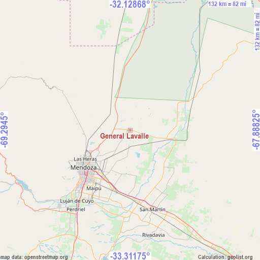
General Lavalle GPS coordinates[2]
32° 43' 19.848" South, 68° 35' 28.932" West
| Map corner | latitude | longitude |
|---|---|---|
| Upper-left | -32.12868°, | -69.2945° |
| Center: | -32.72218°, | -68.59137° |
| Lower-right: | -33.31175°, | -67.88825° |
| Map W x H: | 131.5×131.5 km | = 81.7×81.7mi |
| max Lat: | -21.94467° ⇑58.9% North |
| General Lavalle: | -32.72218° |
| min Lat: | ⇓41.1% South -54.81084° |
| min Long | General Lavalle | max Long |
| -72.88605° | -68.59137° | -53.64581° |
| W 7%⇐ | ⇒93% E |
Elevation
Elevation of General Lavalle is 609 m = 1998 ft, and this is 259.7 m = 852 ft above average elevation for this country.
| Max E: |
4040 m = 13255 ft | 18% |
| General Lavalle | 609 m 1998 ft | |
| Avg. | 349.3 m = 1146 ft | |
Min E: |
-2 m = -7 ft | 82% |
See also: Argentina elevation on elevation.city.
Geographical zone
General Lavalle is located in South temperate zone (between Tropic of Capricorn and the Antarctic Circle). Distance of this Southern Tropic circle is 1032.4 km =641.5 mi to North.| Distance of | km | miles | from General Lavalle |
|---|---|---|---|
| Equator | 3638.4 | 2260.8 | to North |
| Tropic Capricorn | 1032.4 | 641.5 | to North |
| Antarctic Circle | 3762.8 | 2338.1 | to South |
| South Pole | 6368.7 | 3957.3 | to South |


Nearby cities:
15 places around General Lavalle: (largest is in red/bold)
• Godoy Cruz
32.3 km =20.1 mi,  224°
224°
• Junín
48.5 km =30.1 mi,  167°
167°
• Las Heras
26.5 km =16.5 mi,  236°
236°
• Luján de Cuyo
43.9 km =27.3 mi, 217°
• Maipú
33.8 km =21 mi,  212°
212°
• Mendoza
28.9 km =18 mi,  229°
229°
• Primero de Mayo
53.2 km =33.1 mi,  17°
17°
• Rivadavia
53.5 km =33.2 mi, 166°
• San Martín
41.5 km =25.8 mi,  163°
163°
• Santa Rosa
72.1 km =44.8 mi,  145°
145°
• Tunuyán
102.9 km =63.9 mi,  202°
202°
• Tupungato
88.9 km =55.2 mi, 215°
• Villa Media Agua
83.7 km =52 mi,  10°
10°
• Villa Nueva
26.3 km =16.3 mi, 222°
• Villa Santa Rosa
111.8 km =69.5 mi, 13°
Sources, notices
• [Note1] Compared only with cities in Argentina existing in our database
• [Src1] Map data: © OpenStreetMap contributors (CC-BY-SA)
• [Src2] Other city data from geonames.org with taken over terms of usage.
• [Src3] Geographical zone / Annual Mean Temperature by Robert A. Rohde @ Wikipedia
