Tunuyán geodata
Tunuyán (Mendoza) is a seat of a second-order administrative division; located in Argentina in America/Argentina/Mendoza (GMT-3) time zone. In our database, there are 785 cities with bigger population. Compared to other cities in Argentina, 66.8% of cities are located further ↑North; 94.5% of cities are located further →East and 90.1% of cities have lower elevation than Tunuyán. Note1


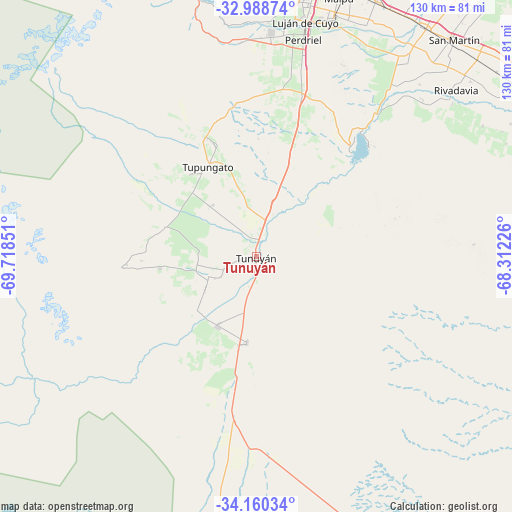
Tunuyán GPS coordinates[2]
33° 34' 35.508" South, 69° 0' 55.368" West
| Map corner | latitude | longitude |
|---|---|---|
| Upper-left | -32.98874°, | -69.71851° |
| Center: | -33.57653°, | -69.01538° |
| Lower-right: | -34.16034°, | -68.31226° |
| Map W x H: | 130.3×130.3 km | = 81×81mi |
| max Lat: | -21.94467° ⇑66.8% North |
| Tunuyán: | -33.57653° |
| min Lat: | ⇓33.2% South -54.81084° |
| min Long | Tunuyán | max Long |
| -72.88605° | -69.01538° | -53.64581° |
| W 5.5%⇐ | ⇒94.5% E |
Elevation
Elevation of Tunuyán is 883 m = 2897 ft, and this is 533.7 m = 1751 ft above average elevation for this country.
| Max E: |
4040 m = 13255 ft | 9.9% |
| Tunuyán | 883 m 2897 ft | |
| Avg. | 349.3 m = 1146 ft | |
Min E: |
-2 m = -7 ft | 90.1% |
See also: Argentina elevation on elevation.city.
Geographical zone
Tunuyán is located in South temperate zone (between Tropic of Capricorn and the Antarctic Circle). Distance of this Southern Tropic circle is 1127.4 km =700.5 mi to North.| Distance of | km | miles | from Tunuyán |
|---|---|---|---|
| Equator | 3733.4 | 2319.8 | to North |
| Tropic Capricorn | 1127.4 | 700.5 | to North |
| Antarctic Circle | 3667.8 | 2279.1 | to South |
| South Pole | 6273.7 | 3898.3 | to South |


Nearby cities:
15 places around Tunuyán: (largest is in red/bold)
• General Lavalle
102.9 km =63.9 mi,  22°
22°
• Godoy Cruz
74 km =46 mi,  13°
13°
• Junín
69 km =42.9 mi,  46°
46°
• La Consulta
20.3 km =12.6 mi,  209°
209°
• La Paz
136.5 km =84.8 mi,  84°
84°
• Las Heras
82.3 km =51.1 mi, 12°
• Luján de Cuyo
61.5 km =38.2 mi, 11°
• Maipú
69.7 km =43.3 mi, 17°
• Mendoza
78.2 km =48.6 mi, 12°
• Rivadavia
67 km =41.6 mi, 50°
• San Martín
75 km =46.6 mi,  42°
42°
• San Rafael
131.8 km =81.9 mi,  151°
151°
• Santa Rosa
88 km =54.7 mi,  65°
65°
• Tupungato
25.9 km =16.1 mi,  331°
331°
• Villa Nueva
78.6 km =48.8 mi, 16°
Sources, notices
• [Note1] Compared only with cities in Argentina existing in our database
• [Src1] Map data: © OpenStreetMap contributors (CC-BY-SA)
• [Src2] Other city data from geonames.org with taken over terms of usage.
• [Src3] Geographical zone / Annual Mean Temperature by Robert A. Rohde @ Wikipedia
