Tupungato geodata
Tupungato (Mendoza) is a seat of a second-order administrative division; located in Argentina in America/Argentina/Mendoza (GMT-3) time zone. In our database, there are 785 cities with bigger population. Compared to other cities in Argentina, 65.7% of cities are located further ↑North; 95% of cities are located further →East and 93.1% of cities have lower elevation than Tupungato. Note1


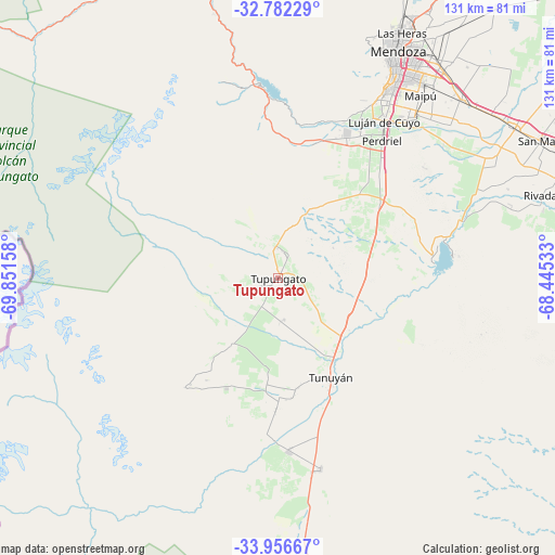
Tupungato GPS coordinates[2]
33° 22' 17.256" South, 69° 8' 54.42" West
| Map corner | latitude | longitude |
|---|---|---|
| Upper-left | -32.78229°, | -69.85158° |
| Center: | -33.37146°, | -69.14845° |
| Lower-right: | -33.95667°, | -68.44533° |
| Map W x H: | 130.6×130.6 km | = 81.2×81.2mi |
| max Lat: | -21.94467° ⇑65.7% North |
| Tupungato: | -33.37146° |
| min Lat: | ⇓34.3% South -54.81084° |
| min Long | Tupungato | max Long |
| -72.88605° | -69.14845° | -53.64581° |
| W 5%⇐ | ⇒95% E |
Elevation
Elevation of Tupungato is 1077 m = 3533 ft, and this is 727.7 m = 2387 ft above average elevation for this country.
| Max E: |
4040 m = 13255 ft | 6.9% |
| Tupungato | 1077 m 3533 ft | |
| Avg. | 349.3 m = 1146 ft | |
Min E: |
-2 m = -7 ft | 93.1% |
See also: Argentina elevation on elevation.city.
Geographical zone
Tupungato is located in South temperate zone (between Tropic of Capricorn and the Antarctic Circle). Distance of this Southern Tropic circle is 1104.6 km =686.4 mi to North.| Distance of | km | miles | from Tupungato |
|---|---|---|---|
| Equator | 3710.6 | 2305.7 | to North |
| Tropic Capricorn | 1104.6 | 686.4 | to North |
| Antarctic Circle | 3690.6 | 2293.2 | to South |
| South Pole | 6296.5 | 3912.5 | to South |


Nearby cities:
15 places around Tupungato: (largest is in red/bold)
• General Lavalle
88.9 km =55.2 mi,  35°
35°
• Godoy Cruz
57.2 km =35.5 mi,  30°
30°
• Junín
67 km =41.6 mi,  68°
68°
• La Consulta
40.6 km =25.2 mi,  176°
176°
• La Paz
148.7 km =92.4 mi,  93°
93°
• Las Heras
64.9 km =40.3 mi, 27°
• Luján de Cuyo
45.1 km =28 mi, 33°
• Maipú
55.2 km =34.3 mi, 37°
• Mendoza
61.2 km =38 mi, 29°
• Primero de Mayo
140.6 km =87.4 mi, 29°
• Rivadavia
67 km =41.6 mi, 72°
• San Martín
71 km =44.1 mi,  62°
62°
• Santa Rosa
93.7 km =58.2 mi,  81°
81°
• Tunuyán
25.9 km =16.1 mi,  151°
151°
• Villa Nueva
62.9 km =39.1 mi, 33°
Sources, notices
• [Note1] Compared only with cities in Argentina existing in our database
• [Src1] Map data: © OpenStreetMap contributors (CC-BY-SA)
• [Src2] Other city data from geonames.org with taken over terms of usage.
• [Src3] Geographical zone / Annual Mean Temperature by Robert A. Rohde @ Wikipedia
