Junín geodata
Junín (Mendoza) is a seat of a second-order administrative division; located in Argentina in America/Argentina/Mendoza (GMT-3) time zone. In our database, there are 785 cities with bigger population. Compared to other cities in Argentina, 63.7% of cities are located further ↑North; 91.9% of cities are located further →East and 84.6% of cities have lower elevation than Junín. Note1


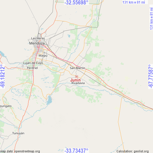
Junín GPS coordinates[2]
33° 8' 51.54" South, 68° 28' 44.364" West
| Map corner | latitude | longitude |
|---|---|---|
| Upper-left | -32.55698°, | -69.18212° |
| Center: | -33.14765°, | -68.47899° |
| Lower-right: | -33.73437°, | -67.77587° |
| Map W x H: | 130.9×130.9 km | = 81.3×81.3mi |
| max Lat: | -21.94467° ⇑63.7% North |
| Junín: | -33.14765° |
| min Lat: | ⇓36.3% South -54.81084° |
| min Long | Junín | max Long |
| -72.88605° | -68.47899° | -53.64581° |
| W 8.1%⇐ | ⇒91.9% E |
Elevation
Elevation of Junín is 669 m = 2195 ft, and this is 319.7 m = 1049 ft above average elevation for this country.
| Max E: |
4040 m = 13255 ft | 15.4% |
| Junín | 669 m 2195 ft | |
| Avg. | 349.3 m = 1146 ft | |
Min E: |
-2 m = -7 ft | 84.6% |
See also: Argentina elevation on elevation.city.
Geographical zone
Junín is located in South temperate zone (between Tropic of Capricorn and the Antarctic Circle). Distance of this Southern Tropic circle is 1079.8 km =671 mi to North.| Distance of | km | miles | from Junín |
|---|---|---|---|
| Equator | 3685.7 | 2290.2 | to North |
| Tropic Capricorn | 1079.8 | 671 | to North |
| Antarctic Circle | 3715.5 | 2308.7 | to South |
| South Pole | 6321.4 | 3927.9 | to South |


Nearby cities:
15 places around Junín: (largest is in red/bold)
• General Lavalle
48.5 km =30.1 mi,  347°
347°
• Godoy Cruz
41.2 km =25.6 mi,  306°
306°
• La Consulta
88.5 km =55 mi,  222°
222°
• La Paz
93.1 km =57.8 mi,  111°
111°
• Las Heras
46.2 km =28.7 mi,  315°
315°
• Luján de Cuyo
39.2 km =24.4 mi,  288°
288°
• Maipú
34.1 km =21.2 mi,  303°
303°
• Mendoza
43.2 km =26.8 mi, 311°
• Primero de Mayo
98.1 km =61 mi,  3°
3°
• Rivadavia
5.1 km =3.2 mi,  160°
160°
• San Martín
7.5 km =4.7 mi,  7°
7°
• Santa Rosa
32.9 km =20.4 mi, 111°
• Tunuyán
69 km =42.9 mi,  226°
226°
• Tupungato
67 km =41.6 mi,  248°
248°
• Villa Nueva
39.6 km =24.6 mi, 314°
Sources, notices
• [Note1] Compared only with cities in Argentina existing in our database
• [Src1] Map data: © OpenStreetMap contributors (CC-BY-SA)
• [Src2] Other city data from geonames.org with taken over terms of usage.
• [Src3] Geographical zone / Annual Mean Temperature by Robert A. Rohde @ Wikipedia
