General Enrique Mosconi geodata
General Enrique Mosconi (Salta) is a populated place; located in Argentina in America/Argentina/Salta (GMT-3) time zone. With population of 19,811 people, there are 187 cities with bigger population in this country. Compared to other cities in Argentina, 99.5% of cities are located further ↓South; 59.2% of cities are located further →East and 76.6% of cities have lower elevation than General Enrique Mosconi. Note1
Current local time in General Enrique Mosconi:
01:10 PM, SaturdayDifference from your time zone: hours


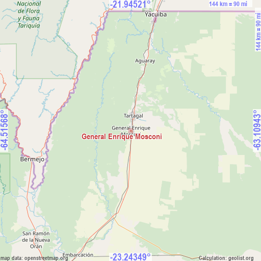
General Enrique Mosconi GPS coordinates[2]
22° 35' 45.168" South, 63° 48' 45.18" West
| Map corner | latitude | longitude |
|---|---|---|
| Upper-left | -21.94521°, | -64.51568° |
| Center: | -22.59588°, | -63.81255° |
| Lower-right: | -23.24349°, | -63.10943° |
| Map W x H: | 144.4×144.4 km | = 89.7×89.7mi |
| max Lat: | -21.94467° ⇑0.5% North |
| General Enrique Mosconi: | -22.59588° |
| min Lat: | ⇓99.5% South -54.81084° |
| min Long | General Enrique | max Long |
| -72.88605° | -63.81255° | -53.64581° |
| W 40.8%⇐ | ⇒59.2% E |
Elevation
Elevation of General Enrique Mosconi is 481 m = 1578 ft, and this is 131.7 m = 432 ft above average elevation for this country.
| Max E: |
4040 m = 13255 ft | 23.4% |
| General Enrique Mosconi | 481 m 1578 ft | |
| Avg. | 349.3 m = 1146 ft | |
Min E: |
-2 m = -7 ft | 76.6% |
See also: Argentina elevation on elevation.city.
Geographical zone
General Enrique Mosconi is located in South Torrid zone (between Equator and Tropic of Capricorn). Distance of this Southern Tropic circle is 93.5 km =58.1 mi to South.| Distance of | km | miles | from General Enrique Mosconi |
|---|---|---|---|
| Equator | 2512.4 | 1561.1 | to North |
| Tropic Capricorn | 93.5 | 58.1 | to South |
| Antarctic Circle | 4888.7 | 3037.7 | to South |
| South Pole | 7494.6 | 4656.9 | to South |


Nearby cities:
15 places around General Enrique Mosconi: (largest is in red/bold)
• Caimancito
150.3 km =93.4 mi,  212°
212°
• Calilegua
163.5 km =101.6 mi,  216°
216°
• Embarcación
74.3 km =46.2 mi,  203°
203°
• Fraile Pintado
180.3 km =112 mi, 213°
• General Enrique Mosconi
169.6 km =105.4 mi,  114°
114°
• Humahuaca
171.5 km =106.6 mi,  246°
246°
• Iruya
145.7 km =90.5 mi,  261°
261°
• La Quiaca
191.1 km =118.7 mi,  286°
286°
• Libertador General San Martín
167.5 km =104.1 mi, 216°
• Palma Sola
161.6 km =100.4 mi, 198°
• San Ramón de la Nueva Orán
79.8 km =49.6 mi, 221°
• Santa Victoria
124.5 km =77.4 mi, 287°
• Tartagal
8.9 km =5.5 mi,  7°
7°
• Valle Grande
151.9 km =94.4 mi,  229°
229°
• Yuto
134.6 km =83.6 mi, 210°
Sources, notices
• [Note1] Compared only with cities in Argentina existing in our database
• [Src1] Map data: © OpenStreetMap contributors (CC-BY-SA)
• [Src2] Other city data from geonames.org with taken over terms of usage.
• [Src3] Geographical zone / Annual Mean Temperature by Robert A. Rohde @ Wikipedia
