General Arenales geodata
General Arenales (Buenos Aires) is a seat of a second-order administrative division; located in Argentina in America/Argentina/Buenos_Aires (GMT-3) time zone. In our database, there are 785 cities with bigger population. Compared to other cities in Argentina, 70% of cities are located further ↑North; 58.9% of cities are located further ←West and 66.6% of cities have higher elevation than General Arenales. Note1


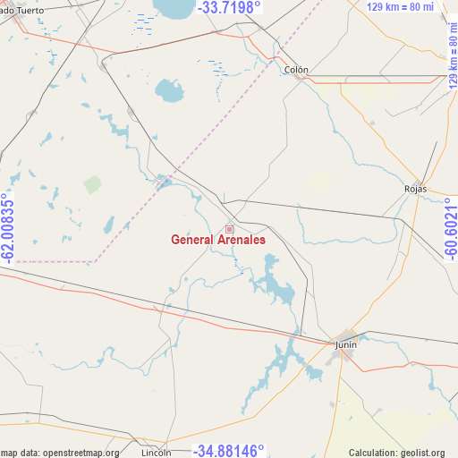
General Arenales GPS coordinates[2]
34° 18' 9.504" South, 61° 18' 18.792" West
| Map corner | latitude | longitude |
|---|---|---|
| Upper-left | -33.7198°, | -62.00835° |
| Center: | -34.30264°, | -61.30522° |
| Lower-right: | -34.88146°, | -60.6021° |
| Map W x H: | 129.2×129.2 km | = 80.3×80.3mi |
| max Lat: | -21.94467° ⇑70% North |
| General Arenales: | -34.30264° |
| min Lat: | ⇓30% South -54.81084° |
| min Long | General Arenale | max Long |
| -72.88605° | -61.30522° | -53.64581° |
| W 58.9%⇐ | ⇒41.1% E |
Elevation
Elevation of General Arenales is 90 m = 295 ft, and this is 259.3 m = 851 ft below average elevation for this country.
| Max E: |
4040 m = 13255 ft | 66.6% |
| Avg. | 349.3 m = 1146 ft | |
| General Arenales | 90 m = 295 ft | |
Min E: |
-2 m = -7 ft | 33.4% |
See also: Argentina elevation on elevation.city.
Geographical zone
General Arenales is located in South temperate zone (between Tropic of Capricorn and the Antarctic Circle). Distance of this Southern Tropic circle is 1208.2 km =750.7 mi to North.| Distance of | km | miles | from General Arenales |
|---|---|---|---|
| Equator | 3814.1 | 2370 | to North |
| Tropic Capricorn | 1208.2 | 750.7 | to North |
| Antarctic Circle | 3587.1 | 2228.9 | to South |
| South Pole | 6193 | 3848.2 | to South |


Nearby cities:
15 places around General Arenales: (largest is in red/bold)
• Chacabuco
85 km =52.8 mi,  116°
116°
• Colón
49.1 km =30.5 mi,  22°
22°
• Firmat
95.2 km =59.2 mi,  350°
350°
• General Pinto
74.3 km =46.2 mi,  226°
226°
• General Viamonte
81.4 km =50.6 mi,  162°
162°
• Junín
45.6 km =28.3 mi,  133°
133°
• Lincoln
66 km =41 mi,  198°
198°
• Melincué
72.9 km =45.3 mi, 349°
• Pergamino
81.5 km =50.6 mi,  55°
55°
• Rojas
53.8 km =33.4 mi,  77°
77°
• Salto
96.5 km =60 mi,  89°
89°
• Vedia
30.5 km =19 mi, 225°
• Venado Tuerto
87 km =54.1 mi,  315°
315°
• Villa Cañás
43.2 km =26.8 mi, 319°
• Villa Mugueta
112.6 km =70 mi,  11°
11°
Sources, notices
• [Note1] Compared only with cities in Argentina existing in our database
• [Src1] Map data: © OpenStreetMap contributors (CC-BY-SA)
• [Src2] Other city data from geonames.org with taken over terms of usage.
• [Src3] Geographical zone / Annual Mean Temperature by Robert A. Rohde @ Wikipedia
