Pergamino geodata
Pergamino (Buenos Aires) is a seat of a second-order administrative division; located in Argentina in America/Argentina/Buenos_Aires (GMT-3) time zone. With population of 87,652 people, there are 46 cities with bigger population in this country. Compared to other cities in Argentina, 68.4% of cities are located further ↑North; 64.3% of cities are located further ←West and 74.9% of cities have higher elevation than Pergamino. Note1


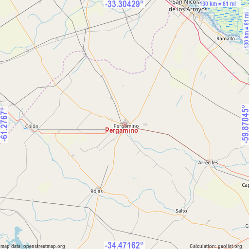
Pergamino GPS coordinates[2]
33° 53' 23.82" South, 60° 34' 24.852" West
| Map corner | latitude | longitude |
|---|---|---|
| Upper-left | -33.30429°, | -61.2767° |
| Center: | -33.88995°, | -60.57357° |
| Lower-right: | -34.47162°, | -59.87045° |
| Map W x H: | 129.8×129.8 km | = 80.7×80.7mi |
| max Lat: | -21.94467° ⇑68.4% North |
| Pergamino: | -33.88995° |
| min Lat: | ⇓31.6% South -54.81084° |
| min Long | Pergamino | max Long |
| -72.88605° | -60.57357° | -53.64581° |
| W 64.3%⇐ | ⇒35.7% E |
Elevation
Elevation of Pergamino is 69 m = 226 ft, and this is 280.3 m = 920 ft below average elevation for this country.
| Max E: |
4040 m = 13255 ft | 74.9% |
| Avg. | 349.3 m = 1146 ft | |
| Pergamino | 69 m = 226 ft | |
Min E: |
-2 m = -7 ft | 25.1% |
See also: Pergamino elevation on elevation.city.
Geographical zone
Pergamino is located in South temperate zone (between Tropic of Capricorn and the Antarctic Circle). Distance of this Southern Tropic circle is 1162.3 km =722.2 mi to North.| Distance of | km | miles | from Pergamino |
|---|---|---|---|
| Equator | 3768.2 | 2341.5 | to North |
| Tropic Capricorn | 1162.3 | 722.2 | to North |
| Antarctic Circle | 3633 | 2257.4 | to South |
| South Pole | 6238.9 | 3876.7 | to South |


Nearby cities:
15 places around Pergamino: (largest is in red/bold)
• Arrecifes
47.5 km =29.5 mi,  114°
114°
• Arroyo Seco
82 km =51 mi,  4°
4°
• Capitán Sarmiento
78.7 km =48.9 mi, 113°
• Chacabuco
84.1 km =52.3 mi,  173°
173°
• Colón
48.7 km =30.3 mi,  269°
269°
• General Arenales
81.5 km =50.6 mi,  235°
235°
• Junín
84.3 km =52.4 mi,  203°
203°
• Melincué
85.4 km =53.1 mi,  287°
287°
• Ramallo
69.1 km =42.9 mi,  49°
49°
• Rojas
37.1 km =23.1 mi, 203°
• Salto
53.6 km =33.3 mi,  146°
146°
• San Nicolás de los Arroyos
70.3 km =43.7 mi,  28°
28°
• San Pedro
87.1 km =54.1 mi,  74°
74°
• Villa Constitución
77 km =47.8 mi,  17°
17°
• Villa Mugueta
78.3 km =48.7 mi,  325°
325°
Sources, notices
• [Note1] Compared only with cities in Argentina existing in our database
• [Src1] Map data: © OpenStreetMap contributors (CC-BY-SA)
• [Src2] Other city data from geonames.org with taken over terms of usage.
• [Src3] Geographical zone / Annual Mean Temperature by Robert A. Rohde @ Wikipedia
