General Viamonte geodata
General Viamonte (Buenos Aires) is a seat of a second-order administrative division; located in Argentina in America/Argentina/Buenos_Aires (GMT-3) time zone. In our database, there are 785 cities with bigger population. Compared to other cities in Argentina, 77.4% of cities are located further ↑North; 60.9% of cities are located further ←West and 73.2% of cities have higher elevation than General Viamonte. Note1


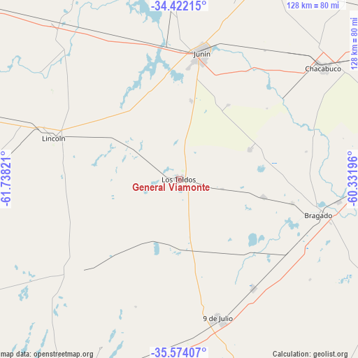
General Viamonte GPS coordinates[2]
35° 0' 0.504" South, 61° 2' 6.288" West
| Map corner | latitude | longitude |
|---|---|---|
| Upper-left | -34.42215°, | -61.73821° |
| Center: | -35.00014°, | -61.03508° |
| Lower-right: | -35.57407°, | -60.33196° |
| Map W x H: | 128.1×128.1 km | = 79.6×79.6mi |
| max Lat: | -21.94467° ⇑77.4% North |
| General Viamonte: | -35.00014° |
| min Lat: | ⇓22.6% South -54.81084° |
| min Long | General Viamont | max Long |
| -72.88605° | -61.03508° | -53.64581° |
| W 60.9%⇐ | ⇒39.1% E |
Elevation
Elevation of General Viamonte is 73 m = 240 ft, and this is 276.3 m = 906 ft below average elevation for this country.
| Max E: |
4040 m = 13255 ft | 73.2% |
| Avg. | 349.3 m = 1146 ft | |
| General Viamonte | 73 m = 240 ft | |
Min E: |
-2 m = -7 ft | 26.8% |
See also: Argentina elevation on elevation.city.
Geographical zone
General Viamonte is located in South temperate zone (between Tropic of Capricorn and the Antarctic Circle). Distance of this Southern Tropic circle is 1285.7 km =798.9 mi to North.| Distance of | km | miles | from General Viamonte |
|---|---|---|---|
| Equator | 3891.7 | 2418.2 | to North |
| Tropic Capricorn | 1285.7 | 798.9 | to North |
| Antarctic Circle | 3509.5 | 2180.7 | to South |
| South Pole | 6115.4 | 3799.9 | to South |


Nearby cities:
15 places around General Viamonte: (largest is in red/bold)
• Alberti
69.2 km =43 mi,  92°
92°
• Bragado
51.4 km =31.9 mi,  104°
104°
• Carlos Casares
75.2 km =46.7 mi,  203°
203°
• Chacabuco
64.9 km =40.3 mi,  52°
52°
• Chivilcoy
93.5 km =58.1 mi,  82°
82°
• General Arenales
81.4 km =50.6 mi,  342°
342°
• General Pinto
82.3 km =51.1 mi,  288°
288°
• Junín
47 km =29.2 mi,  10°
10°
• Lincoln
47.5 km =29.5 mi, 288°
• Nueve de Julio
51.3 km =31.9 mi,  164°
164°
• Pehuajó
119.3 km =74.1 mi,  220°
220°
• Rojas
93.6 km =58.2 mi,  17°
17°
• Salto
106.2 km =66 mi,  42°
42°
• Vedia
72.7 km =45.2 mi,  320°
320°
• Veinticinco de Mayo
91.9 km =57.1 mi,  121°
121°
Sources, notices
• [Note1] Compared only with cities in Argentina existing in our database
• [Src1] Map data: © OpenStreetMap contributors (CC-BY-SA)
• [Src2] Other city data from geonames.org with taken over terms of usage.
• [Src3] Geographical zone / Annual Mean Temperature by Robert A. Rohde @ Wikipedia
