Burruyacú geodata
Burruyacú (Tucuman) is a seat of a second-order administrative division; located in Argentina in America/Argentina/Tucuman (GMT-3) time zone. With population of 2,037 people, there are 643 cities with bigger population in this country. Compared to other cities in Argentina, 90.4% of cities are located further ↓South; 70.5% of cities are located further →East and 78.4% of cities have lower elevation than Burruyacú. Note1


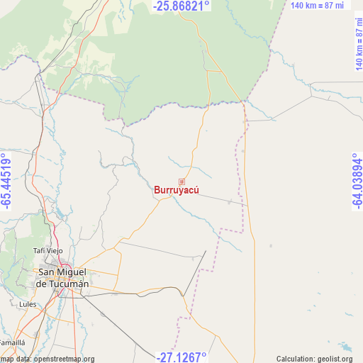
Burruyacú GPS coordinates[2]
26° 29' 57.048" South, 64° 44' 31.416" West
| Map corner | latitude | longitude |
|---|---|---|
| Upper-left | -25.86821°, | -65.44519° |
| Center: | -26.49918°, | -64.74206° |
| Lower-right: | -27.1267°, | -64.03894° |
| Map W x H: | 139.9×139.9 km | = 86.9×86.9mi |
| max Lat: | -21.94467° ⇑9.6% North |
| Burruyacú: | -26.49918° |
| min Lat: | ⇓90.4% South -54.81084° |
| min Long | Burruyacú | max Long |
| -72.88605° | -64.74206° | -53.64581° |
| W 29.5%⇐ | ⇒70.5% E |
Elevation
Elevation of Burruyacú is 526 m = 1726 ft, and this is 176.7 m = 580 ft above average elevation for this country.
| Max E: |
4040 m = 13255 ft | 21.6% |
| Burruyacú | 526 m 1726 ft | |
| Avg. | 349.3 m = 1146 ft | |
Min E: |
-2 m = -7 ft | 78.4% |
See also: Argentina elevation on elevation.city.
Geographical zone
Burruyacú is located in South temperate zone (between Tropic of Capricorn and the Antarctic Circle). Distance of this Southern Tropic circle is 340.5 km =211.6 mi to North.| Distance of | km | miles | from Burruyacú |
|---|---|---|---|
| Equator | 2946.4 | 1830.8 | to North |
| Tropic Capricorn | 340.5 | 211.6 | to North |
| Antarctic Circle | 4454.7 | 2768 | to South |
| South Pole | 7060.6 | 4387.3 | to South |


Nearby cities:
15 places around Burruyacú: (largest is in red/bold)
• Alderetes
52.5 km =32.6 mi,  227°
227°
• Banda del Río Salí
56.2 km =34.9 mi, 228°
• Bella Vista
81.4 km =50.6 mi,  223°
223°
• Famaillá
90.1 km =56 mi, 226°
• La Candelaria
51.5 km =32 mi,  323°
323°
• Nueva Esperanza
60.3 km =37.5 mi,  56°
56°
• Pozo Hondo
78.3 km =48.7 mi,  161°
161°
• Rosario de la Frontera
81.4 km =50.6 mi,  343°
343°
• San Isidro de Lules
76 km =47.2 mi, 231°
• San Miguel de Tucumán
59.9 km =37.2 mi, 232°
• Simoca
104.5 km =64.9 mi, 215°
• Tafí Viejo
57.6 km =35.8 mi,  243°
243°
• Tafí del Valle
103.9 km =64.6 mi,  247°
247°
• Trancas
61.4 km =38.2 mi,  299°
299°
• Yerba Buena
67.1 km =41.7 mi, 238°
Sources, notices
• [Note1] Compared only with cities in Argentina existing in our database
• [Src1] Map data: © OpenStreetMap contributors (CC-BY-SA)
• [Src2] Other city data from geonames.org with taken over terms of usage.
• [Src3] Geographical zone / Annual Mean Temperature by Robert A. Rohde @ Wikipedia
