Trancas geodata
Trancas (Tucuman) is a seat of a second-order administrative division; located in Argentina in America/Argentina/Tucuman (GMT-3) time zone. With population of 6,658 people, there are 377 cities with bigger population in this country. Compared to other cities in Argentina, 91.5% of cities are located further ↓South; 75.1% of cities are located further →East and 87.9% of cities have lower elevation than Trancas. Note1


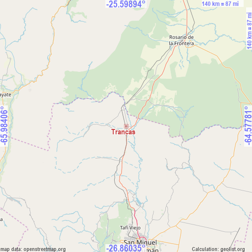
Trancas GPS coordinates[2]
26° 13' 52.896" South, 65° 16' 51.348" West
| Map corner | latitude | longitude |
|---|---|---|
| Upper-left | -25.59894°, | -65.98406° |
| Center: | -26.23136°, | -65.28093° |
| Lower-right: | -26.86035°, | -64.57781° |
| Map W x H: | 140.3×140.3 km | = 87.2×87.2mi |
| max Lat: | -21.94467° ⇑8.5% North |
| Trancas: | -26.23136° |
| min Lat: | ⇓91.5% South -54.81084° |
| min Long | Trancas | max Long |
| -72.88605° | -65.28093° | -53.64581° |
| W 24.9%⇐ | ⇒75.1% E |
Elevation
Elevation of Trancas is 780 m = 2559 ft, and this is 430.7 m = 1413 ft above average elevation for this country.
| Max E: |
4040 m = 13255 ft | 12.1% |
| Trancas | 780 m 2559 ft | |
| Avg. | 349.3 m = 1146 ft | |
Min E: |
-2 m = -7 ft | 87.9% |
See also: Argentina elevation on elevation.city.
Geographical zone
Trancas is located in South temperate zone (between Tropic of Capricorn and the Antarctic Circle). Distance of this Southern Tropic circle is 310.7 km =193.1 mi to North.| Distance of | km | miles | from Trancas |
|---|---|---|---|
| Equator | 2916.7 | 1812.4 | to North |
| Tropic Capricorn | 310.7 | 193.1 | to North |
| Antarctic Circle | 4484.5 | 2786.5 | to South |
| South Pole | 7090.4 | 4405.8 | to South |


Nearby cities:
15 places around Trancas: (largest is in red/bold)
• Alderetes
66.7 km =41.4 mi,  167°
167°
• Banda del Río Salí
67.9 km =42.2 mi, 170°
• Bella Vista
89.3 km =55.5 mi,  181°
181°
• Burruyacú
61.4 km =38.2 mi,  119°
119°
• Cafayate
71.7 km =44.6 mi,  284°
284°
• Guachipas
82.3 km =51.1 mi,  343°
343°
• La Candelaria
25.8 km =16 mi,  63°
63°
• Metán
87 km =54.1 mi,  20°
20°
• Rosario de la Frontera
57.4 km =35.7 mi,  32°
32°
• San Carlos
75.3 km =46.8 mi,  300°
300°
• San Isidro de Lules
77.6 km =48.2 mi, 184°
• San Miguel de Tucumán
66.2 km =41.1 mi, 174°
• Tafí Viejo
55.7 km =34.6 mi, 177°
• Tafí del Valle
81.2 km =50.5 mi,  211°
211°
• Yerba Buena
65.2 km =40.5 mi, 183°
Sources, notices
• [Note1] Compared only with cities in Argentina existing in our database
• [Src1] Map data: © OpenStreetMap contributors (CC-BY-SA)
• [Src2] Other city data from geonames.org with taken over terms of usage.
• [Src3] Geographical zone / Annual Mean Temperature by Robert A. Rohde @ Wikipedia
