General Cabrera geodata
General Cabrera (Cordoba) is a populated place; located in Argentina in America/Argentina/Cordoba (GMT-3) time zone. With population of 10,351 people, there are 286 cities with bigger population in this country. Compared to other cities in Argentina, 59.6% of cities are located further ↑North; 59.7% of cities are located further →East and 67.3% of cities have lower elevation than General Cabrera. Note1


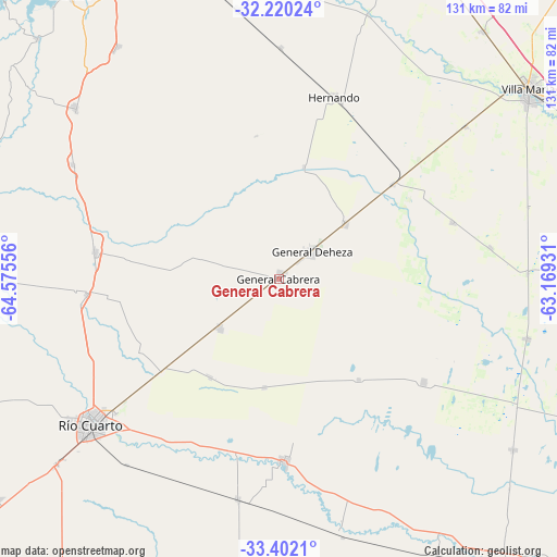
General Cabrera GPS coordinates[2]
32° 48' 47.268" South, 63° 52' 20.748" West
| Map corner | latitude | longitude |
|---|---|---|
| Upper-left | -32.22024°, | -64.57556° |
| Center: | -32.81313°, | -63.87243° |
| Lower-right: | -33.4021°, | -63.16931° |
| Map W x H: | 131.4×131.4 km | = 81.6×81.6mi |
| max Lat: | -21.94467° ⇑59.6% North |
| General Cabrera: | -32.81313° |
| min Lat: | ⇓40.4% South -54.81084° |
| min Long | General Cabrera | max Long |
| -72.88605° | -63.87243° | -53.64581° |
| W 40.3%⇐ | ⇒59.7% E |
Elevation
Elevation of General Cabrera is 298 m = 978 ft, and this is 51.3 m = 168 ft below average elevation for this country.
| Max E: |
4040 m = 13255 ft | 32.7% |
| Avg. | 349.3 m = 1146 ft | |
| General Cabrera | 298 m = 978 ft | |
Min E: |
-2 m = -7 ft | 67.3% |
See also: Argentina elevation on elevation.city.
Geographical zone
General Cabrera is located in South temperate zone (between Tropic of Capricorn and the Antarctic Circle). Distance of this Southern Tropic circle is 1042.6 km =647.8 mi to North.| Distance of | km | miles | from General Cabrera |
|---|---|---|---|
| Equator | 3648.5 | 2267.1 | to North |
| Tropic Capricorn | 1042.6 | 647.8 | to North |
| Antarctic Circle | 3752.7 | 2331.8 | to South |
| South Pole | 6358.6 | 3951 | to South |


Nearby cities:
15 places around General Cabrera: (largest is in red/bold)
• Arroyo Cabral
56.8 km =35.3 mi,  50°
50°
• Carnerillo
17.9 km =11.1 mi,  231°
231°
• Charras
28.6 km =17.8 mi,  214°
214°
• Coronel Baigorria
45.8 km =28.5 mi,  265°
265°
• Dalmacio Vélez Sársfield
35.4 km =22 mi, 50°
• Elena
55.7 km =34.6 mi,  298°
298°
• Hernando
44.9 km =27.9 mi,  16°
16°
• Las Acequias
53 km =32.9 mi,  190°
190°
• Las Higueras
49.7 km =30.9 mi, 231°
• Las Perdices
20.1 km =12.5 mi, 50°
• Pasco
50.1 km =31.1 mi,  81°
81°
• Río Cuarto
56.8 km =35.3 mi, 231°
• Ticino
42.9 km =26.7 mi,  71°
71°
• Ucacha
41.9 km =26 mi,  125°
125°
• Villa Reducción
43.1 km =26.8 mi,  178°
178°
Sources, notices
• [Note1] Compared only with cities in Argentina existing in our database
• [Src1] Map data: © OpenStreetMap contributors (CC-BY-SA)
• [Src2] Other city data from geonames.org with taken over terms of usage.
• [Src3] Geographical zone / Annual Mean Temperature by Robert A. Rohde @ Wikipedia
