Rettenbach geodata
Rettenbach (Upper Austria) is a populated place; located in Austria in Europe/Vienna (GMT+2) time zone. With population of 533 people, there are 2383 cities with bigger population in this country. Compared to other cities in Austria, 54.8% of cities are located further ↓South; 72.1% of cities are located further →East and 51.6% of cities have lower elevation than Rettenbach. Note1
Administrative division(s):
- Level 1: Upper Austria
- Level 2: Politischer Bezirk Gmunden
- Level 3: Bad Ischl


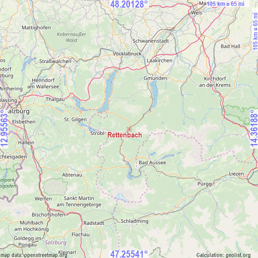
Rettenbach GPS coordinates[2]
47° 43' 49.764" North, 13° 39' 31.5" East
| Map corner | latitude | longitude |
|---|---|---|
| Upper-left | 48.20128°, | 12.95563° |
| Center: | 47.73049°, | 13.65875° |
| Lower-right: | 47.25541°, | 14.36188° |
| Map W x H: | 105.2×105.2 km | = 65.4×65.4mi |
| max Lat: | 48.98333° ⇑45.2% North |
| Rettenbach: | 47.73049° |
| min Lat: | ⇓54.8% South 46.48841° |
| min Long | Rettenbach | max Long |
| 9.57802° | 13.65875° | 17.1° |
| W 27.9%⇐ | ⇒72.1% E |
Elevation
Elevation of Rettenbach is 460 m = 1509 ft, and this is 45.5 m = 149 ft below average elevation for this country.
| Max E: |
2140 m = 7021 ft | 48.4% |
| Avg. | 505.5 m = 1658 ft | |
| Rettenbach | 460 m = 1509 ft | |
Min E: |
118 m = 387 ft | 51.6% |
See also: Austria elevation on elevation.city.
Geographical zone
Rettenbach is located in North temperate zone (between Tropic of Cancer and the Arctic Circle). Distance of this North polar circle is 2094 km =1301.2 mi to North.| Distance of | km | miles | from Rettenbach |
|---|---|---|---|
| North Pole | 4699.9 | 2920.4 | to North |
| Arctic Circle | 2094 | 1301.2 | to North |
| Tropic Cancer | 2701.2 | 1678.4 | to South |
| Equator | 5307.1 | 3297.7 | to South |


Nearby cities:
15 places around Rettenbach: (largest is in red/bold)
• Ahorn
4.6 km =2.9 mi,  243°
243°
• Aigen
10 km =6.2 mi,  250°
250°
• Bad Goisern
10.3 km =6.4 mi,  198°
198°
• Bad Ischl
3.7 km =2.3 mi,  234°
234°
• Ebensee
12.4 km =7.7 mi,  46°
46°
• Gschwandt
11.4 km =7.1 mi, 195°
• Haiden
6.9 km =4.3 mi,  258°
258°
• Jainzen
3.5 km =2.2 mi, 243°
• Kaltenbach
4.6 km =2.9 mi, 233°
• Kreutern
5.2 km =3.2 mi, 258°
• Langwies
5.9 km =3.7 mi, 47°
• Reiterndorf
3.7 km =2.3 mi,  216°
216°
• Roith
9 km =5.6 mi, 49°
• Steinfeld
2.8 km =1.7 mi, 224°
• Sulzbach
4.9 km =3 mi, 217°
Sources, notices
• [Note1] Compared only with cities in Austria existing in our database
• [Src1] Map data: © OpenStreetMap contributors (CC-BY-SA)
• [Src2] Other city data from geonames.org with taken over terms of usage.
• [Src3] Geographical zone / Annual Mean Temperature by Robert A. Rohde @ Wikipedia
