Gschwandt geodata
Gschwandt (Upper Austria) is a populated place; located in Austria in Europe/Vienna (GMT+1) time zone. With population of 645 people, there are 1997 cities with bigger population in this country. Compared to other cities in Austria, 51.3% of cities are located further ↓South; 73.1% of cities are located further →East and 66.9% of cities have lower elevation than Gschwandt. Note1
Administrative division(s):
- Level 1: Upper Austria
- Level 2: Politischer Bezirk Gmunden
- Level 3: Bad Goisern


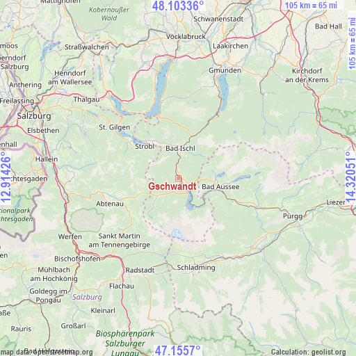
Gschwandt GPS coordinates[2]
47° 37' 54.048" North, 13° 37' 2.568" East
| Map corner | latitude | longitude |
|---|---|---|
| Upper-left | 48.10336°, | 12.91426° |
| Center: | 47.63168°, | 13.61738° |
| Lower-right: | 47.1557°, | 14.32051° |
| Map W x H: | 105.4×105.4 km | = 65.5×65.5mi |
| max Lat: | 48.98333° ⇑48.7% North |
| Gschwandt: | 47.63168° |
| min Lat: | ⇓51.3% South 46.48841° |
| min Long | Gschwandt | max Long |
| 9.57802° | 13.61738° | 17.1° |
| W 26.9%⇐ | ⇒73.1% E |
Elevation
Elevation of Gschwandt is 565 m = 1854 ft, and this is 59.5 m = 195 ft above average elevation for this country.
| Max E: |
2140 m = 7021 ft | 33.1% |
| Gschwandt | 565 m 1854 ft | |
| Avg. | 505.5 m = 1658 ft | |
Min E: |
118 m = 387 ft | 66.9% |
See also: Austria elevation on elevation.city.
Geographical zone
Gschwandt is located in North temperate zone (between Tropic of Cancer and the Arctic Circle). Distance of this North polar circle is 2105 km =1308 mi to North.| Distance of | km | miles | from Gschwandt |
|---|---|---|---|
| North Pole | 4710.9 | 2927.2 | to North |
| Arctic Circle | 2105 | 1308 | to North |
| Tropic Cancer | 2690.2 | 1671.6 | to South |
| Equator | 5296.1 | 3290.8 | to South |


Nearby cities:
15 places around Gschwandt: (largest is in red/bold)
• Ahorn
9 km =5.6 mi,  353°
353°
• Aigen
9.9 km =6.2 mi,  320°
320°
• Bad Goisern
1.2 km =0.7 mi,  355°
355°
• Bad Ischl
8.8 km =5.5 mi,  0°
0°
• Gosau
8.2 km =5.1 mi,  229°
229°
• Haiden
10.2 km =6.3 mi,  339°
339°
• Jainzen
9.5 km =5.9 mi, 359°
• Kaltenbach
8.3 km =5.2 mi, 355°
• Kreutern
10.2 km =6.3 mi, 348°
• Obertraun
9.7 km =6 mi,  147°
147°
• Puchen
10.7 km =6.6 mi,  88°
88°
• Reiterndorf
8 km =5 mi,  6°
6°
• Steinfeld
9.1 km =5.7 mi, 7°
• Sulzbach
7.1 km =4.4 mi, 1°
• Untersee
3 km =1.9 mi,  124°
124°
Sources, notices
• [Note1] Compared only with cities in Austria existing in our database
• [Src1] Map data: © OpenStreetMap contributors (CC-BY-SA)
• [Src2] Other city data from geonames.org with taken over terms of usage.
• [Src3] Geographical zone / Annual Mean Temperature by Robert A. Rohde @ Wikipedia
