Bad Goisern geodata
Bad Goisern (Upper Austria) is a populated place; located in Austria in Europe/Vienna (GMT+2) time zone. With population of 1,987 people, there are 618 cities with bigger population in this country. Compared to other cities in Austria, 51.7% of cities are located further ↓South; 73.2% of cities are located further →East and 57% of cities have lower elevation than Bad Goisern. Note1
Administrative division(s):
- Level 1: Upper Austria
- Level 2: Politischer Bezirk Gmunden
- Level 3: Bad Goisern


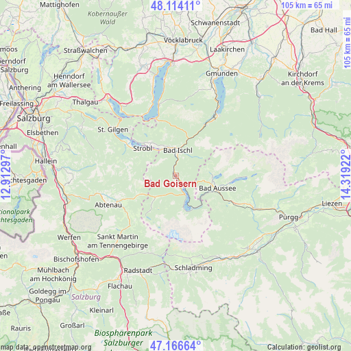
Bad Goisern GPS coordinates[2]
47° 38' 33.072" North, 13° 36' 57.924" East
| Map corner | latitude | longitude |
|---|---|---|
| Upper-left | 48.11411°, | 12.91297° |
| Center: | 47.64252°, | 13.61609° |
| Lower-right: | 47.16664°, | 14.31922° |
| Map W x H: | 105.3×105.3 km | = 65.4×65.4mi |
| max Lat: | 48.98333° ⇑48.3% North |
| Bad Goisern: | 47.64252° |
| min Lat: | ⇓51.7% South 46.48841° |
| min Long | Bad Goisern | max Long |
| 9.57802° | 13.61609° | 17.1° |
| W 26.8%⇐ | ⇒73.2% E |
Elevation
Elevation of Bad Goisern is 498 m = 1634 ft, and this is 7.5 m = 25 ft below average elevation for this country.
| Max E: |
2140 m = 7021 ft | 43% |
| Avg. | 505.5 m = 1658 ft | |
| Bad Goisern | 498 m = 1634 ft | |
Min E: |
118 m = 387 ft | 57% |
See also: Austria elevation on elevation.city.
Geographical zone
Bad Goisern is located in North temperate zone (between Tropic of Cancer and the Arctic Circle). Distance of this North polar circle is 2103.8 km =1307.2 mi to North.| Distance of | km | miles | from Bad Goisern |
|---|---|---|---|
| North Pole | 4709.7 | 2926.5 | to North |
| Arctic Circle | 2103.8 | 1307.2 | to North |
| Tropic Cancer | 2691.4 | 1672.4 | to South |
| Equator | 5297.4 | 3291.7 | to South |


Nearby cities:
15 places around Bad Goisern: (largest is in red/bold)
• Ahorn
7.8 km =4.8 mi,  352°
352°
• Aigen
8.9 km =5.5 mi,  315°
315°
• Bad Ischl
7.6 km =4.7 mi,  1°
1°
• Gosau
8.9 km =5.5 mi,  223°
223°
• Gschwandt
1.2 km =0.7 mi,  175°
175°
• Haiden
9.1 km =5.7 mi,  337°
337°
• Jainzen
8.2 km =5.1 mi, 0°
• Kaltenbach
7.1 km =4.4 mi,  355°
355°
• Kreutern
9 km =5.6 mi, 347°
• Obertraun
10.8 km =6.7 mi,  150°
150°
• Reiterndorf
6.9 km =4.3 mi,  8°
8°
• Rettenbach
10.3 km =6.4 mi,  18°
18°
• Steinfeld
7.9 km =4.9 mi, 9°
• Sulzbach
5.9 km =3.7 mi, 2°
• Untersee
3.8 km =2.4 mi,  138°
138°
In other languages:
- In France: Bad Goisern am Hallstättersee
- In German: Bad Goisern am Hallstättersee
- In Italian: Bad Goisern am Hallstättersee
- In Russian: Бад-Гойзерн
- In Chinese: 巴特戈伊瑟恩
Sources, notices
• [Note1] Compared only with cities in Austria existing in our database
• [Src1] Map data: © OpenStreetMap contributors (CC-BY-SA)
• [Src2] Other city data from geonames.org with taken over terms of usage.
• [Src3] Geographical zone / Annual Mean Temperature by Robert A. Rohde @ Wikipedia
