Weitensfeld geodata
Weitensfeld (Carinthia) is a seat of a third-order administrative division; located in Austria in Europe/Vienna (GMT+2) time zone. With population of 565 people, there are 2267 cities with bigger population in this country. Compared to other cities in Austria, 89.8% of cities are located further ↑North; 60.7% of cities are located further →East and 79.1% of cities have lower elevation than Weitensfeld. Note1
Administrative division(s):
- Level 1: Carinthia
- Level 2: Politischer Bezirk Sankt Veit an der Glan
- Level 3: Weitensfeld im Gurktal


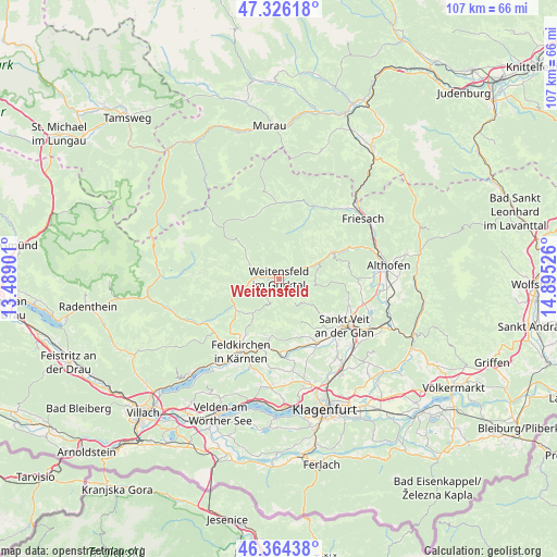
Weitensfeld GPS coordinates[2]
46° 50' 50.748" North, 14° 11' 31.668" East
| Map corner | latitude | longitude |
|---|---|---|
| Upper-left | 47.32618°, | 13.48901° |
| Center: | 46.84743°, | 14.19213° |
| Lower-right: | 46.36438°, | 14.89526° |
| Map W x H: | 106.9×106.9 km | = 66.4×66.4mi |
| max Lat: | 48.98333° ⇑89.8% North |
| Weitensfeld: | 46.84743° |
| min Lat: | ⇓10.2% South 46.48841° |
| min Long | Weitensfeld | max Long |
| 9.57802° | 14.19213° | 17.1° |
| W 39.3%⇐ | ⇒60.7% E |
Elevation
Elevation of Weitensfeld is 701 m = 2300 ft, and this is 195.5 m = 641 ft above average elevation for this country.
| Max E: |
2140 m = 7021 ft | 20.9% |
| Weitensfeld | 701 m 2300 ft | |
| Avg. | 505.5 m = 1658 ft | |
Min E: |
118 m = 387 ft | 79.1% |
See also: Austria elevation on elevation.city.
Geographical zone
Weitensfeld is located in North temperate zone (between Tropic of Cancer and the Arctic Circle). Distance of this North polar circle is 2192.2 km =1362.2 mi to North.| Distance of | km | miles | from Weitensfeld |
|---|---|---|---|
| North Pole | 4798.1 | 2981.4 | to North |
| Arctic Circle | 2192.2 | 1362.2 | to North |
| Tropic Cancer | 2603 | 1617.4 | to South |
| Equator | 5208.9 | 3236.7 | to South |


Nearby cities:
15 places around Weitensfeld: (largest is in red/bold)
• Deutsch Griffen
9 km =5.6 mi,  276°
276°
• Draschen
12.9 km =8 mi,  227°
227°
• Frauenstein
8.6 km =5.3 mi,  115°
115°
• Glanegg
13.9 km =8.6 mi,  177°
177°
• Glödnitz
6.3 km =3.9 mi,  298°
298°
• Gurk
8.1 km =5 mi,  68°
68°
• Kraig
14 km =8.7 mi,  105°
105°
• Liebenfels
14.2 km =8.8 mi,  149°
149°
• Mauer
12.2 km =7.6 mi,  166°
166°
• Mautbrücken
14.1 km =8.8 mi, 179°
• Sankt Ruprecht
14.7 km =9.1 mi,  207°
207°
• Sankt Ulrich
12.3 km =7.6 mi, 207°
• Seitenberg
13.6 km =8.5 mi,  215°
215°
• Steuerberg
8.9 km =5.5 mi, 222°
• Straßburg-Stadt
11.6 km =7.2 mi,  63°
63°
Sources, notices
• [Note1] Compared only with cities in Austria existing in our database
• [Src1] Map data: © OpenStreetMap contributors (CC-BY-SA)
• [Src2] Other city data from geonames.org with taken over terms of usage.
• [Src3] Geographical zone / Annual Mean Temperature by Robert A. Rohde @ Wikipedia
