Weer geodata
Weer (Tyrol) is a seat of a third-order administrative division; located in Austria in Europe/Vienna (GMT+2) time zone. With population of 1,539 people, there are 816 cities with bigger population in this country. Compared to other cities in Austria, 64.9% of cities are located further ↑North; 90.7% of cities are located further →East and 73.4% of cities have lower elevation than Weer. Note1


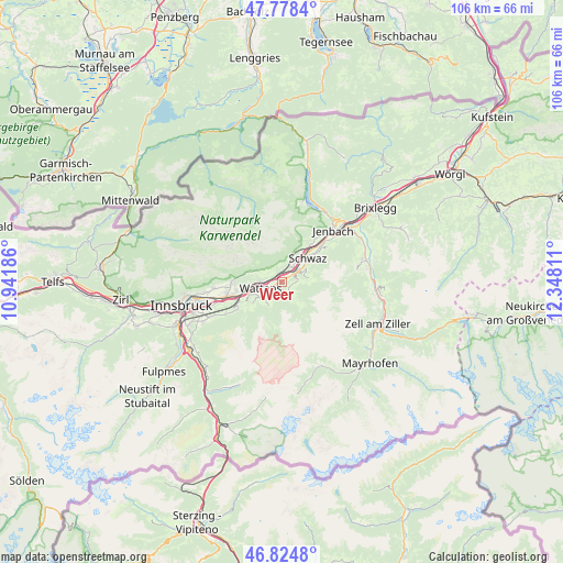
Weer GPS coordinates[2]
47° 18' 13.5" North, 11° 38' 41.928" East
| Map corner | latitude | longitude |
|---|---|---|
| Upper-left | 47.7784°, | 10.94186° |
| Center: | 47.30375°, | 11.64498° |
| Lower-right: | 46.8248°, | 12.34811° |
| Map W x H: | 106×106 km | = 65.9×65.9mi |
| max Lat: | 48.98333° ⇑64.9% North |
| Weer: | 47.30375° |
| min Lat: | ⇓35.1% South 46.48841° |
| min Long | Weer | max Long |
| 9.57802° | 11.64498° | 17.1° |
| W 9.3%⇐ | ⇒90.7% E |
Elevation
Elevation of Weer is 631 m = 2070 ft, and this is 125.5 m = 412 ft above average elevation for this country.
| Max E: |
2140 m = 7021 ft | 26.6% |
| Weer | 631 m 2070 ft | |
| Avg. | 505.5 m = 1658 ft | |
Min E: |
118 m = 387 ft | 73.4% |
See also: Austria elevation on elevation.city.
Geographical zone
Weer is located in North temperate zone (between Tropic of Cancer and the Arctic Circle). Distance of this North polar circle is 2141.5 km =1330.7 mi to North.| Distance of | km | miles | from Weer |
|---|---|---|---|
| North Pole | 4747.4 | 2949.9 | to North |
| Arctic Circle | 2141.5 | 1330.7 | to North |
| Tropic Cancer | 2653.8 | 1649 | to South |
| Equator | 5259.7 | 3268.2 | to South |


Nearby cities:
15 places around Weer: (largest is in red/bold)
• Baumkirchen
5.9 km =3.7 mi,  265°
265°
• Fiecht
6.6 km =4.1 mi,  38°
38°
• Fritzens
4.2 km =2.6 mi, 272°
• Gnadenwald
6.1 km =3.8 mi,  283°
283°
• Kolsass
1 km =0.6 mi,  244°
244°
• Kolsassberg
2.5 km =1.6 mi,  166°
166°
• Neu-Terfens
1.5 km =0.9 mi,  330°
330°
• Pill
3.4 km =2.1 mi,  50°
50°
• Terfens
2.2 km =1.4 mi,  357°
357°
• Volders
6.3 km =3.9 mi,  248°
248°
• Vomp
4.4 km =2.7 mi, 41°
• Vomperbach
3.7 km =2.3 mi,  26°
26°
• Wattenberg
4.1 km =2.5 mi, 236°
• Wattens
4.2 km =2.6 mi,  255°
255°
• Weerberg
1.7 km =1.1 mi,  110°
110°
Sources, notices
• [Note1] Compared only with cities in Austria existing in our database
• [Src1] Map data: © OpenStreetMap contributors (CC-BY-SA)
• [Src2] Other city data from geonames.org with taken over terms of usage.
• [Src3] Geographical zone / Annual Mean Temperature by Robert A. Rohde @ Wikipedia
