Kolsassberg geodata
Kolsassberg (Tyrol) is a seat of a third-order administrative division; located in Austria in Europe/Vienna (GMT+2) time zone. With population of 817 people, there are 1582 cities with bigger population in this country. Compared to other cities in Austria, 67.3% of cities are located further ↑North; 90.7% of cities are located further →East and 91.1% of cities have lower elevation than Kolsassberg. Note1
Administrative division(s):
- Level 1: Tyrol
- Level 2: Politischer Bezirk Innsbruck Land
- Level 3: Kolsassberg


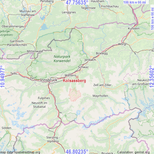
Kolsassberg GPS coordinates[2]
47° 16' 53.4" North, 11° 39' 10.404" East
| Map corner | latitude | longitude |
|---|---|---|
| Upper-left | 47.75635°, | 10.94977° |
| Center: | 47.2815°, | 11.65289° |
| Lower-right: | 46.80235°, | 12.35602° |
| Map W x H: | 106.1×106.1 km | = 65.9×65.9mi |
| max Lat: | 48.98333° ⇑67.3% North |
| Kolsassberg: | 47.2815° |
| min Lat: | ⇓32.7% South 46.48841° |
| min Long | Kolsassberg | max Long |
| 9.57802° | 11.65289° | 17.1° |
| W 9.3%⇐ | ⇒90.7% E |
Elevation
Elevation of Kolsassberg is 905 m = 2969 ft, and this is 399.5 m = 1311 ft above average elevation for this country.
| Max E: |
2140 m = 7021 ft | 8.9% |
| Kolsassberg | 905 m 2969 ft | |
| Avg. | 505.5 m = 1658 ft | |
Min E: |
118 m = 387 ft | 91.1% |
See also: Austria elevation on elevation.city.
Geographical zone
Kolsassberg is located in North temperate zone (between Tropic of Cancer and the Arctic Circle). Distance of this North polar circle is 2144 km =1332.2 mi to North.| Distance of | km | miles | from Kolsassberg |
|---|---|---|---|
| North Pole | 4749.9 | 2951.5 | to North |
| Arctic Circle | 2144 | 1332.2 | to North |
| Tropic Cancer | 2651.3 | 1647.4 | to South |
| Equator | 5257.2 | 3266.7 | to South |


Nearby cities:
15 places around Kolsassberg: (largest is in red/bold)
• Baumkirchen
6.8 km =4.2 mi,  287°
287°
• Fiecht
8.4 km =5.2 mi,  24°
24°
• Fritzens
5.5 km =3.4 mi,  299°
299°
• Gnadenwald
7.6 km =4.7 mi, 301°
• Kolsass
2.5 km =1.6 mi,  324°
324°
• Neu-Terfens
4 km =2.5 mi,  340°
340°
• Pill
5.1 km =3.2 mi, 23°
• Terfens
4.7 km =2.9 mi,  351°
351°
• Volders
6.5 km =4 mi,  271°
271°
• Vomp
6.2 km =3.9 mi, 21°
• Vomperbach
5.9 km =3.7 mi,  10°
10°
• Wattenberg
4 km =2.5 mi, 272°
• Wattens
4.9 km =3 mi, 286°
• Weer
2.5 km =1.6 mi, 346°
• Weerberg
2.1 km =1.3 mi,  27°
27°
Sources, notices
• [Note1] Compared only with cities in Austria existing in our database
• [Src1] Map data: © OpenStreetMap contributors (CC-BY-SA)
• [Src2] Other city data from geonames.org with taken over terms of usage.
• [Src3] Geographical zone / Annual Mean Temperature by Robert A. Rohde @ Wikipedia
