Wattens geodata
Wattens (Tyrol) is a seat of a third-order administrative division; located in Austria in Europe/Vienna (GMT+2) time zone. With population of 7,881 people, there are 114 cities with bigger population in this country. Compared to other cities in Austria, 65.9% of cities are located further ↑North; 90.9% of cities are located further →East and 65.4% of cities have lower elevation than Wattens. Note1
Administrative division(s):
- Level 1: Tyrol
- Level 2: Politischer Bezirk Innsbruck Land
- Level 3: Wattens


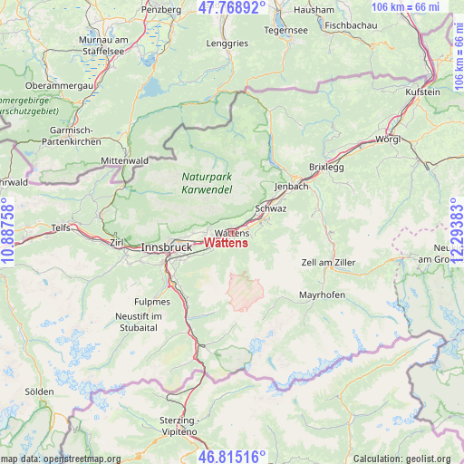
Wattens GPS coordinates[2]
47° 17' 39.084" North, 11° 35' 26.52" East
| Map corner | latitude | longitude |
|---|---|---|
| Upper-left | 47.76892°, | 10.88758° |
| Center: | 47.29419°, | 11.5907° |
| Lower-right: | 46.81516°, | 12.29383° |
| Map W x H: | 106×106 km | = 65.9×65.9mi |
| max Lat: | 48.98333° ⇑65.9% North |
| Wattens: | 47.29419° |
| min Lat: | ⇓34.1% South 46.48841° |
| min Long | Wattens | max Long |
| 9.57802° | 11.5907° | 17.1° |
| W 9.1%⇐ | ⇒90.9% E |
Elevation
Elevation of Wattens is 555 m = 1821 ft, and this is 49.5 m = 162 ft above average elevation for this country.
| Max E: |
2140 m = 7021 ft | 34.6% |
| Wattens | 555 m 1821 ft | |
| Avg. | 505.5 m = 1658 ft | |
Min E: |
118 m = 387 ft | 65.4% |
See also: Austria elevation on elevation.city.
Geographical zone
Wattens is located in North temperate zone (between Tropic of Cancer and the Arctic Circle). Distance of this North polar circle is 2142.6 km =1331.3 mi to North.| Distance of | km | miles | from Wattens |
|---|---|---|---|
| North Pole | 4748.4 | 2950.5 | to North |
| Arctic Circle | 2142.6 | 1331.3 | to North |
| Tropic Cancer | 2652.7 | 1648.3 | to South |
| Equator | 5258.6 | 3267.5 | to South |


Nearby cities:
15 places around Wattens: (largest is in red/bold)
• Absam
6.4 km =4 mi,  271°
271°
• Baumkirchen
1.9 km =1.2 mi,  289°
289°
• Fritzens
1.2 km =0.7 mi,  355°
355°
• Gnadenwald
3.1 km =1.9 mi,  324°
324°
• Hall in Tirol
5.7 km =3.5 mi,  257°
257°
• Kolsass
3.3 km =2.1 mi,  78°
78°
• Kolsassberg
4.9 km =3 mi,  106°
106°
• Mils bei Solbad Hall
4.5 km =2.8 mi,  254°
254°
• Neu-Terfens
4.1 km =2.5 mi,  55°
55°
• Terfens
5.2 km =3.2 mi,  50°
50°
• Tulfes
5.9 km =3.7 mi,  227°
227°
• Volders
2.2 km =1.4 mi,  236°
236°
• Wattenberg
1.4 km =0.9 mi,  149°
149°
• Weer
4.2 km =2.6 mi, 75°
• Weerberg
5.7 km =3.5 mi,  85°
85°
Sources, notices
• [Note1] Compared only with cities in Austria existing in our database
• [Src1] Map data: © OpenStreetMap contributors (CC-BY-SA)
• [Src2] Other city data from geonames.org with taken over terms of usage.
• [Src3] Geographical zone / Annual Mean Temperature by Robert A. Rohde @ Wikipedia
