Fritzens geodata
Fritzens (Tyrol) is a seat of a third-order administrative division; located in Austria in Europe/Vienna (GMT+2) time zone. With population of 2,148 people, there are 567 cities with bigger population in this country. Compared to other cities in Austria, 64.8% of cities are located further ↑North; 90.9% of cities are located further →East and 64.5% of cities have lower elevation than Fritzens. Note1
Administrative division(s):
- Level 1: Tyrol
- Level 2: Politischer Bezirk Innsbruck Land
- Level 3: Fritzens


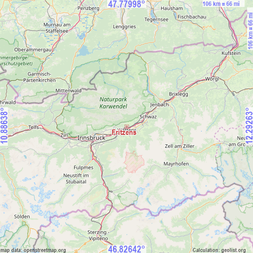
Fritzens GPS coordinates[2]
47° 18' 19.26" North, 11° 35' 22.2" East
| Map corner | latitude | longitude |
|---|---|---|
| Upper-left | 47.77998°, | 10.88638° |
| Center: | 47.30535°, | 11.5895° |
| Lower-right: | 46.82642°, | 12.29263° |
| Map W x H: | 106×106 km | = 65.9×65.9mi |
| max Lat: | 48.98333° ⇑64.8% North |
| Fritzens: | 47.30535° |
| min Lat: | ⇓35.2% South 46.48841° |
| min Long | Fritzens | max Long |
| 9.57802° | 11.5895° | 17.1° |
| W 9.1%⇐ | ⇒90.9% E |
Elevation
Elevation of Fritzens is 549 m = 1801 ft, and this is 43.5 m = 143 ft above average elevation for this country.
| Max E: |
2140 m = 7021 ft | 35.5% |
| Fritzens | 549 m 1801 ft | |
| Avg. | 505.5 m = 1658 ft | |
Min E: |
118 m = 387 ft | 64.5% |
See also: Austria elevation on elevation.city.
Geographical zone
Fritzens is located in North temperate zone (between Tropic of Cancer and the Arctic Circle). Distance of this North polar circle is 2141.3 km =1330.5 mi to North.| Distance of | km | miles | from Fritzens |
|---|---|---|---|
| North Pole | 4747.2 | 2949.8 | to North |
| Arctic Circle | 2141.3 | 1330.5 | to North |
| Tropic Cancer | 2653.9 | 1649.1 | to South |
| Equator | 5259.9 | 3268.3 | to South |


Nearby cities:
15 places around Fritzens: (largest is in red/bold)
• Absam
6.4 km =4 mi,  260°
260°
• Baumkirchen
1.8 km =1.1 mi,  250°
250°
• Gnadenwald
2.1 km =1.3 mi,  306°
306°
• Hall in Tirol
6 km =3.7 mi, 245°
• Kolsass
3.4 km =2.1 mi,  100°
100°
• Kolsassberg
5.5 km =3.4 mi,  119°
119°
• Mils bei Solbad Hall
4.9 km =3 mi,  239°
239°
• Neu-Terfens
3.6 km =2.2 mi,  72°
72°
• Terfens
4.6 km =2.9 mi,  63°
63°
• Volders
3 km =1.9 mi,  215°
215°
• Vomperbach
6.6 km =4.1 mi, 61°
• Wattenberg
2.6 km =1.6 mi,  162°
162°
• Wattens
1.2 km =0.7 mi,  175°
175°
• Weer
4.2 km =2.6 mi,  92°
92°
• Weerberg
5.8 km =3.6 mi, 97°
Sources, notices
• [Note1] Compared only with cities in Austria existing in our database
• [Src1] Map data: © OpenStreetMap contributors (CC-BY-SA)
• [Src2] Other city data from geonames.org with taken over terms of usage.
• [Src3] Geographical zone / Annual Mean Temperature by Robert A. Rohde @ Wikipedia
