Grünbach am Schneeberg geodata
Grünbach am Schneeberg (Lower Austria) is a seat of a third-order administrative division; located in Austria in Europe/Vienna (GMT+2) time zone. With population of 1,480 people, there are 851 cities with bigger population in this country. Compared to other cities in Austria, 56.9% of cities are located further ↓South; 79.9% of cities are located further ←West and 64.7% of cities have lower elevation than Grünbach am Schneeberg. Note1
Administrative division(s):
- Level 1: Lower Austria
- Level 2: Politischer Bezirk Neunkirchen
- Level 3: Grünbach am Schneeberg


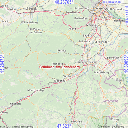
Grünbach am Schneeberg GPS coordinates[2]
47° 47' 50.892" North, 15° 59' 16.26" East
| Map corner | latitude | longitude |
|---|---|---|
| Upper-left | 48.26765°, | 15.28473° |
| Center: | 47.79747°, | 15.98785° |
| Lower-right: | 47.323°, | 16.69098° |
| Map W x H: | 105×105 km | = 65.2×65.2mi |
| max Lat: | 48.98333° ⇑43.1% North |
| Grünbach am Schneeberg: | 47.79747° |
| min Lat: | ⇓56.9% South 46.48841° |
| min Long | Grünbach am Sc | max Long |
| 9.57802° | 15.98785° | 17.1° |
| W 79.9%⇐ | ⇒20.1% E |
Elevation
Elevation of Grünbach am Schneeberg is 550 m = 1804 ft, and this is 44.5 m = 146 ft above average elevation for this country.
| Max E: |
2140 m = 7021 ft | 35.3% |
| Grünbach am Schneeberg | 550 m 1804 ft | |
| Avg. | 505.5 m = 1658 ft | |
Min E: |
118 m = 387 ft | 64.7% |
See also: Austria elevation on elevation.city.
Geographical zone
Grünbach am Schneeberg is located in North temperate zone (between Tropic of Cancer and the Arctic Circle). Distance of this North polar circle is 2086.6 km =1296.6 mi to North.| Distance of | km | miles | from Grünbach am Schneeberg |
|---|---|---|---|
| North Pole | 4692.5 | 2915.8 | to North |
| Arctic Circle | 2086.6 | 1296.6 | to North |
| Tropic Cancer | 2708.7 | 1683.1 | to South |
| Equator | 5314.6 | 3302.3 | to South |


Nearby cities:
15 places around Grünbach am Schneeberg: (largest is in red/bold)
• Maiersdorf
5.6 km =3.5 mi,  65°
65°
• Miesenbach
4.8 km =3 mi,  355°
355°
• Mollram
8.8 km =5.5 mi,  119°
119°
• Muthmannsdorf
10.2 km =6.3 mi,  63°
63°
• Puchberg am Schneeberg
5.7 km =3.5 mi,  258°
258°
• Raglitz
7 km =4.3 mi,  138°
138°
• Saubersdorf
9.8 km =6.1 mi,  95°
95°
• Schrattenbach
2.1 km =1.3 mi,  174°
174°
• Stollhof
7.2 km =4.5 mi, 59°
• Ternitz
9.8 km =6.1 mi,  158°
158°
• Waidmannsfeld
8.1 km =5 mi, 356°
• Waldegg
9.2 km =5.7 mi,  31°
31°
• Willendorf am Steinfelde
5.2 km =3.2 mi, 100°
• Winzendorf
9.5 km =5.9 mi,  80°
80°
• Würflach
5.5 km =3.4 mi, 115°
Sources, notices
• [Note1] Compared only with cities in Austria existing in our database
• [Src1] Map data: © OpenStreetMap contributors (CC-BY-SA)
• [Src2] Other city data from geonames.org with taken over terms of usage.
• [Src3] Geographical zone / Annual Mean Temperature by Robert A. Rohde @ Wikipedia
