Pernitz geodata
Pernitz (Lower Austria) is a seat of a third-order administrative division; located in Austria in Europe/Vienna (GMT+2) time zone. With population of 2,356 people, there are 519 cities with bigger population in this country. Compared to other cities in Austria, 61% of cities are located further ↓South; 79.1% of cities are located further ←West and 53.8% of cities have higher elevation than Pernitz. Note1
Administrative division(s):
- Level 1: Lower Austria
- Level 2: Politischer Bezirk Wiener Neustadt
- Level 3: Pernitz


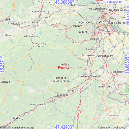
Pernitz GPS coordinates[2]
47° 53' 51.324" North, 15° 57' 36.792" East
| Map corner | latitude | longitude |
|---|---|---|
| Upper-left | 48.36686°, | 15.2571° |
| Center: | 47.89759°, | 15.96022° |
| Lower-right: | 47.42403°, | 16.66335° |
| Map W x H: | 104.8×104.8 km | = 65.1×65.1mi |
| max Lat: | 48.98333° ⇑39% North |
| Pernitz: | 47.89759° |
| min Lat: | ⇓61% South 46.48841° |
| min Long | Pernitz | max Long |
| 9.57802° | 15.96022° | 17.1° |
| W 79.1%⇐ | ⇒20.9% E |
Elevation
Elevation of Pernitz is 429 m = 1407 ft, and this is 76.5 m = 251 ft below average elevation for this country.
| Max E: |
2140 m = 7021 ft | 53.8% |
| Avg. | 505.5 m = 1658 ft | |
| Pernitz | 429 m = 1407 ft | |
Min E: |
118 m = 387 ft | 46.2% |
See also: Austria elevation on elevation.city.
Geographical zone
Pernitz is located in North temperate zone (between Tropic of Cancer and the Arctic Circle). Distance of this North polar circle is 2075.5 km =1289.7 mi to North.| Distance of | km | miles | from Pernitz |
|---|---|---|---|
| North Pole | 4681.3 | 2908.8 | to North |
| Arctic Circle | 2075.5 | 1289.7 | to North |
| Tropic Cancer | 2719.8 | 1690 | to South |
| Equator | 5325.7 | 3309.2 | to South |


Nearby cities:
15 places around Pernitz: (largest is in red/bold)
• Dreistetten
11.4 km =7.1 mi,  114°
114°
• Furth an der Triesting
8.5 km =5.3 mi,  6°
6°
• Grünbach am Schneeberg
11.3 km =7 mi,  169°
169°
• Gutenstein
5.8 km =3.6 mi,  245°
245°
• Hernstein
10.8 km =6.7 mi,  91°
91°
• Maiersdorf
11.3 km =7 mi,  141°
141°
• Miesenbach
6.6 km =4.1 mi, 165°
• Muggendorf
2.4 km =1.5 mi,  307°
307°
• Neusiedl
1.1 km =0.7 mi, 168°
• Oberpiesting
10.6 km =6.6 mi,  103°
103°
• Stollhof
11.1 km =6.9 mi,  132°
132°
• Vorderbruck
4.5 km =2.8 mi,  239°
239°
• Waidmannsfeld
3.4 km =2.1 mi,  152°
152°
• Waldegg
7.5 km =4.7 mi,  115°
115°
• Weissenbach an der Triesting
11.1 km =6.9 mi,  32°
32°
Sources, notices
• [Note1] Compared only with cities in Austria existing in our database
• [Src1] Map data: © OpenStreetMap contributors (CC-BY-SA)
• [Src2] Other city data from geonames.org with taken over terms of usage.
• [Src3] Geographical zone / Annual Mean Temperature by Robert A. Rohde @ Wikipedia
