Vordernberg geodata
Vordernberg (Styria) is a seat of a third-order administrative division; located in Austria in Europe/Vienna (GMT+2) time zone. With population of 1,045 people, there are 1224 cities with bigger population in this country. Compared to other cities in Austria, 54.2% of cities are located further ↑North; 54.2% of cities are located further ←West and 87% of cities have lower elevation than Vordernberg. Note1


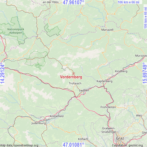
Vordernberg GPS coordinates[2]
47° 29' 17.124" North, 14° 59' 39.696" East
| Map corner | latitude | longitude |
|---|---|---|
| Upper-left | 47.96107°, | 14.29124° |
| Center: | 47.48809°, | 14.99436° |
| Lower-right: | 47.01081°, | 15.69749° |
| Map W x H: | 105.7×105.7 km | = 65.7×65.7mi |
| max Lat: | 48.98333° ⇑54.2% North |
| Vordernberg: | 47.48809° |
| min Lat: | ⇓45.8% South 46.48841° |
| min Long | Vordernberg | max Long |
| 9.57802° | 14.99436° | 17.1° |
| W 54.2%⇐ | ⇒45.8% E |
Elevation
Elevation of Vordernberg is 827 m = 2713 ft, and this is 321.5 m = 1055 ft above average elevation for this country.
| Max E: |
2140 m = 7021 ft | 13% |
| Vordernberg | 827 m 2713 ft | |
| Avg. | 505.5 m = 1658 ft | |
Min E: |
118 m = 387 ft | 87% |
See also: Austria elevation on elevation.city.
Geographical zone
Vordernberg is located in North temperate zone (between Tropic of Cancer and the Arctic Circle). Distance of this North polar circle is 2121 km =1317.9 mi to North.| Distance of | km | miles | from Vordernberg |
|---|---|---|---|
| North Pole | 4726.9 | 2937.2 | to North |
| Arctic Circle | 2121 | 1317.9 | to North |
| Tropic Cancer | 2674.3 | 1661.7 | to South |
| Equator | 5280.2 | 3281 | to South |


Nearby cities:
15 places around Vordernberg: (largest is in red/bold)
• Donawitz
14.6 km =9.1 mi,  158°
158°
• Eisenerz
9.7 km =6 mi,  301°
301°
• Hessenberg
10.2 km =6.3 mi,  170°
170°
• Judendorf
12.6 km =7.8 mi,  140°
140°
• Kammern im Liesingtal
12.6 km =7.8 mi,  212°
212°
• Laintal
7.7 km =4.8 mi,  154°
154°
• Leitendorf
15.1 km =9.4 mi, 153°
• Leoben
14.4 km =8.9 mi, 149°
• Proleb
14.3 km =8.9 mi,  133°
133°
• Sankt Ilgen
14.7 km =9.1 mi,  61°
61°
• Sankt Katharein an der Laming
12.8 km =8 mi,  98°
98°
• Sankt Peter-Freienstein
11.8 km =7.3 mi, 171°
• Timmersdorf
12.3 km =7.6 mi,  186°
186°
• Traboch
12.4 km =7.7 mi,  182°
182°
• Trofaiach
7.1 km =4.4 mi, 172°
Sources, notices
• [Note1] Compared only with cities in Austria existing in our database
• [Src1] Map data: © OpenStreetMap contributors (CC-BY-SA)
• [Src2] Other city data from geonames.org with taken over terms of usage.
• [Src3] Geographical zone / Annual Mean Temperature by Robert A. Rohde @ Wikipedia
