Vöcklamarkt geodata
Vöcklamarkt (Upper Austria) is a seat of a third-order administrative division; located in Austria in Europe/Vienna (GMT+2) time zone. With population of 2,112 people, there are 577 cities with bigger population in this country. Compared to other cities in Austria, 66.3% of cities are located further ↓South; 75.1% of cities are located further →East and 55.4% of cities have lower elevation than Vöcklamarkt. Note1
Administrative division(s):
- Level 1: Upper Austria
- Level 2: Politischer Bezirk Vöcklabruck
- Level 3: Vöcklamarkt


Vöcklamarkt GPS coordinates[2]
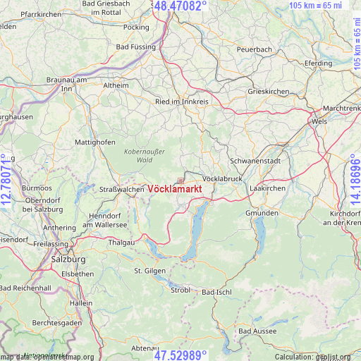
48° 0' 9" North, 13° 29' 1.788" East
| Map corner | latitude | longitude |
|---|---|---|
| Upper-left | 48.47082°, | 12.78071° |
| Center: | 48.0025°, | 13.48383° |
| Lower-right: | 47.52989°, | 14.18696° |
| Map W x H: | 104.6×104.6 km | = 65×65mi |
| max Lat: | 48.98333° ⇑33.7% North |
| Vöcklamarkt: | 48.0025° |
| min Lat: | ⇓66.3% South 46.48841° |
| min Long | Vöcklamarkt | max Long |
| 9.57802° | 13.48383° | 17.1° |
| W 24.9%⇐ | ⇒75.1% E |
Elevation
Elevation of Vöcklamarkt is 488 m = 1601 ft, and this is 17.5 m = 57 ft below average elevation for this country.
| Max E: |
2140 m = 7021 ft | 44.6% |
| Avg. | 505.5 m = 1658 ft | |
| Vöcklamarkt | 488 m = 1601 ft | |
Min E: |
118 m = 387 ft | 55.4% |
See also: Austria elevation on elevation.city.
Geographical zone
Vöcklamarkt is located in North temperate zone (between Tropic of Cancer and the Arctic Circle). Distance of this North polar circle is 2063.8 km =1282.4 mi to North.| Distance of | km | miles | from Vöcklamarkt |
|---|---|---|---|
| North Pole | 4669.7 | 2901.6 | to North |
| Arctic Circle | 2063.8 | 1282.4 | to North |
| Tropic Cancer | 2731.5 | 1697.3 | to South |
| Equator | 5337.4 | 3316.5 | to South |


Nearby cities:
15 places around Vöcklamarkt: (largest is in red/bold)
• Fornach
4.6 km =2.9 mi,  299°
299°
• Frankenburg
7.3 km =4.5 mi,  3°
3°
• Frankenmarkt
5.4 km =3.4 mi,  246°
246°
• Gampern
5.5 km =3.4 mi,  106°
106°
• Lenzing
9.8 km =6.1 mi, 109°
• Neukirchen an der Vöckla
5.8 km =3.6 mi,  43°
43°
• Pfaffing
1.8 km =1.1 mi,  339°
339°
• Pichlwang
9.9 km =6.2 mi,  96°
96°
• Puchlkirchen am Trattberg
8.1 km =5 mi,  54°
54°
• Redleiten
8.8 km =5.5 mi,  352°
352°
• Sankt Georgen im Attergau
7.4 km =4.6 mi,  180°
180°
• Seewalchen
9.3 km =5.8 mi,  126°
126°
• Steindorf
7.9 km =4.9 mi,  124°
124°
• Timelkam
9.2 km =5.7 mi,  89°
89°
• Weißenkirchen im Attergau
7.6 km =4.7 mi,  219°
219°
Sources, notices
• [Note1] Compared only with cities in Austria existing in our database
• [Src1] Map data: © OpenStreetMap contributors (CC-BY-SA)
• [Src2] Other city data from geonames.org with taken over terms of usage.
• [Src3] Geographical zone / Annual Mean Temperature by Robert A. Rohde @ Wikipedia
