Fornach geodata
Fornach (Upper Austria) is a seat of a third-order administrative division; located in Austria in Europe/Vienna (GMT+2) time zone. With population of 223 people, there are 2835 cities with bigger population in this country. Compared to other cities in Austria, 67.9% of cities are located further ↓South; 76.3% of cities are located further →East and 66.5% of cities have lower elevation than Fornach. Note1
Administrative division(s):
- Level 1: Upper Austria
- Level 2: Politischer Bezirk Vöcklabruck
- Level 3: Fornach


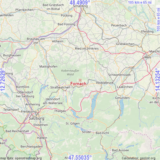
Fornach GPS coordinates[2]
48° 1' 21.972" North, 13° 25' 45.876" East
| Map corner | latitude | longitude |
|---|---|---|
| Upper-left | 48.4909°, | 12.72629° |
| Center: | 48.02277°, | 13.42941° |
| Lower-right: | 47.55035°, | 14.13254° |
| Map W x H: | 104.6×104.6 km | = 65×65mi |
| max Lat: | 48.98333° ⇑32.1% North |
| Fornach: | 48.02277° |
| min Lat: | ⇓67.9% South 46.48841° |
| min Long | Fornach | max Long |
| 9.57802° | 13.42941° | 17.1° |
| W 23.7%⇐ | ⇒76.3% E |
Elevation
Elevation of Fornach is 562 m = 1844 ft, and this is 56.5 m = 185 ft above average elevation for this country.
| Max E: |
2140 m = 7021 ft | 33.5% |
| Fornach | 562 m 1844 ft | |
| Avg. | 505.5 m = 1658 ft | |
Min E: |
118 m = 387 ft | 66.5% |
See also: Austria elevation on elevation.city.
Geographical zone
Fornach is located in North temperate zone (between Tropic of Cancer and the Arctic Circle). Distance of this North polar circle is 2061.5 km =1281 mi to North.| Distance of | km | miles | from Fornach |
|---|---|---|---|
| North Pole | 4667.4 | 2900.2 | to North |
| Arctic Circle | 2061.5 | 1281 | to North |
| Tropic Cancer | 2733.7 | 1698.6 | to South |
| Equator | 5339.6 | 3317.9 | to South |


Nearby cities:
15 places around Fornach: (largest is in red/bold)
• Ampflwang
12.2 km =7.6 mi,  56°
56°
• Frankenburg
6.8 km =4.2 mi,  41°
41°
• Frankenmarkt
4.5 km =2.8 mi,  192°
192°
• Gampern
10 km =6.2 mi,  112°
112°
• Irrsdorf
12.5 km =7.8 mi,  240°
240°
• Neukirchen an der Vöckla
8.3 km =5.2 mi,  76°
76°
• Pfaffing
3.4 km =2.1 mi,  98°
98°
• Puchlkirchen am Trattberg
10.9 km =6.8 mi, 76°
• Redleiten
7.1 km =4.4 mi,  24°
24°
• Sankt Georgen im Attergau
10.4 km =6.5 mi,  157°
157°
• Schneegattern
10.1 km =6.3 mi,  270°
270°
• Siedlung
11.9 km =7.4 mi, 55°
• Steindorf
12.5 km =7.8 mi,  122°
122°
• Vöcklamarkt
4.6 km =2.9 mi, 119°
• Weißenkirchen im Attergau
8.2 km =5.1 mi, 185°
Sources, notices
• [Note1] Compared only with cities in Austria existing in our database
• [Src1] Map data: © OpenStreetMap contributors (CC-BY-SA)
• [Src2] Other city data from geonames.org with taken over terms of usage.
• [Src3] Geographical zone / Annual Mean Temperature by Robert A. Rohde @ Wikipedia
