Sebersdorf geodata
Sebersdorf (Styria) is a seat of a third-order administrative division; located in Austria in Europe/Vienna (GMT+2) time zone. With population of 750 people, there are 1723 cities with bigger population in this country. Compared to other cities in Austria, 73.5% of cities are located further ↑North; 80.2% of cities are located further ←West and 75.8% of cities have higher elevation than Sebersdorf. Note1
Administrative division(s):
- Level 1: Styria
- Level 2: Politischer Bezirk Hartberg-Fürstenfeld
- Level 3: Bad Waltersdorf


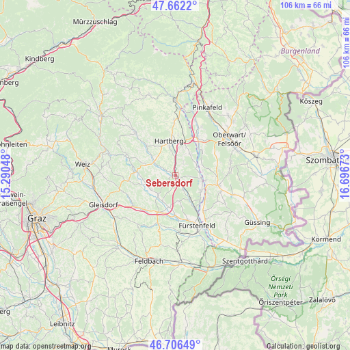
Sebersdorf GPS coordinates[2]
47° 11' 11.4" North, 15° 59' 36.96" East
| Map corner | latitude | longitude |
|---|---|---|
| Upper-left | 47.6622°, | 15.29048° |
| Center: | 47.1865°, | 15.9936° |
| Lower-right: | 46.70649°, | 16.69673° |
| Map W x H: | 106.3×106.3 km | = 66.1×66.1mi |
| max Lat: | 48.98333° ⇑73.5% North |
| Sebersdorf: | 47.1865° |
| min Lat: | ⇓26.5% South 46.48841° |
| min Long | Sebersdorf | max Long |
| 9.57802° | 15.9936° | 17.1° |
| W 80.2%⇐ | ⇒19.8% E |
Elevation
Elevation of Sebersdorf is 298 m = 978 ft, and this is 207.5 m = 681 ft below average elevation for this country.
| Max E: |
2140 m = 7021 ft | 75.8% |
| Avg. | 505.5 m = 1658 ft | |
| Sebersdorf | 298 m = 978 ft | |
Min E: |
118 m = 387 ft | 24.2% |
See also: Austria elevation on elevation.city.
Geographical zone
Sebersdorf is located in North temperate zone (between Tropic of Cancer and the Arctic Circle). Distance of this North polar circle is 2154.5 km =1338.7 mi to North.| Distance of | km | miles | from Sebersdorf |
|---|---|---|---|
| North Pole | 4760.4 | 2958 | to North |
| Arctic Circle | 2154.5 | 1338.7 | to North |
| Tropic Cancer | 2640.7 | 1640.9 | to South |
| Equator | 5246.6 | 3260.1 | to South |


Nearby cities:
15 places around Sebersdorf: (largest is in red/bold)
• Bad Blumau
8.9 km =5.5 mi,  151°
151°
• Bad Waltersdorf
2.2 km =1.4 mi, 148°
• Dienersdorf
9.1 km =5.7 mi,  310°
310°
• Ebersdorf
2.7 km =1.7 mi,  299°
299°
• Grosshart
4 km =2.5 mi,  236°
236°
• Hainersdorf
8.8 km =5.5 mi,  205°
205°
• Hartl
5.8 km =3.6 mi,  266°
266°
• Kaindorf
7.6 km =4.7 mi, 304°
• Leitersdorf bei Hartberg
5 km =3.1 mi,  143°
143°
• Neudau
8.3 km =5.2 mi,  98°
98°
• Safenau
8.9 km =5.5 mi,  355°
355°
• Unterbuch
4.5 km =2.8 mi, 356°
• Unterrohr
8.2 km =5.1 mi,  31°
31°
• Wörterberg
8.7 km =5.4 mi,  67°
67°
• Wörth an der Lafnitz
7.2 km =4.5 mi, 65°
Sources, notices
• [Note1] Compared only with cities in Austria existing in our database
• [Src1] Map data: © OpenStreetMap contributors (CC-BY-SA)
• [Src2] Other city data from geonames.org with taken over terms of usage.
• [Src3] Geographical zone / Annual Mean Temperature by Robert A. Rohde @ Wikipedia
