Übersbach geodata
Übersbach (Styria) is a seat of a third-order administrative division; located in Austria in Europe/Vienna (GMT+2) time zone. With population of 668 people, there are 1940 cities with bigger population in this country. Compared to other cities in Austria, 83% of cities are located further ↑North; 81.9% of cities are located further ←West and 83% of cities have higher elevation than Übersbach. Note1
Administrative division(s):
- Level 1: Styria
- Level 2: Politischer Bezirk Hartberg-Fürstenfeld
- Level 3: Fürstenfeld


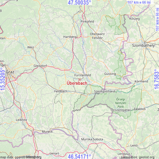
Übersbach GPS coordinates[2]
47° 1' 23.448" North, 16° 3' 18.612" East
| Map corner | latitude | longitude |
|---|---|---|
| Upper-left | 47.50035°, | 15.35205° |
| Center: | 47.02318°, | 16.05517° |
| Lower-right: | 46.54171°, | 16.7583° |
| Map W x H: | 106.6×106.6 km | = 66.2×66.2mi |
| max Lat: | 48.98333° ⇑83% North |
| Übersbach: | 47.02318° |
| min Lat: | ⇓17% South 46.48841° |
| min Long | Übersbach | max Long |
| 9.57802° | 16.05517° | 17.1° |
| W 81.9%⇐ | ⇒18.1% E |
Elevation
Elevation of Übersbach is 258 m = 846 ft, and this is 247.5 m = 812 ft below average elevation for this country.
| Max E: |
2140 m = 7021 ft | 83% |
| Avg. | 505.5 m = 1658 ft | |
| Übersbach | 258 m = 846 ft | |
Min E: |
118 m = 387 ft | 17% |
See also: Austria elevation on elevation.city.
Geographical zone
Übersbach is located in North temperate zone (between Tropic of Cancer and the Arctic Circle). Distance of this North polar circle is 2172.7 km =1350.1 mi to North.| Distance of | km | miles | from Übersbach |
|---|---|---|---|
| North Pole | 4778.6 | 2969.3 | to North |
| Arctic Circle | 2172.7 | 1350.1 | to North |
| Tropic Cancer | 2622.6 | 1629.6 | to South |
| Equator | 5228.5 | 3248.8 | to South |


Nearby cities:
15 places around Übersbach: (largest is in red/bold)
• Altenmarkt bei Fürstenfeld
4.8 km =3 mi,  353°
353°
• Breitenfeld an der Rittschein
8.1 km =5 mi,  278°
278°
• Brunn
8.6 km =5.3 mi,  199°
199°
• Dietersdorf bei Fürstenfeld
3.3 km =2.1 mi,  92°
92°
• Fürstenfeld
3.7 km =2.3 mi,  35°
35°
• Grieselstein
9.3 km =5.8 mi,  147°
147°
• Grosswilfersdorf
8.6 km =5.3 mi,  320°
320°
• Hatzendorf
6.6 km =4.1 mi,  218°
218°
• Hohenbrugg an der Raab
8.4 km =5.2 mi,  171°
171°
• Königsdorf
8.8 km =5.5 mi,  106°
106°
• Loipersdorf bei Fürstenfeld
4.3 km =2.7 mi,  127°
127°
• Rudersdorf
5.5 km =3.4 mi,  57°
57°
• Stein
3.7 km =2.3 mi,  139°
139°
• Söchau
3.1 km =1.9 mi,  291°
291°
• Unterlamm
5.2 km =3.2 mi, 172°
Sources, notices
• [Note1] Compared only with cities in Austria existing in our database
• [Src1] Map data: © OpenStreetMap contributors (CC-BY-SA)
• [Src2] Other city data from geonames.org with taken over terms of usage.
• [Src3] Geographical zone / Annual Mean Temperature by Robert A. Rohde @ Wikipedia
