Fürstenfeld geodata
Fürstenfeld (Styria) is a seat of a third-order administrative division; located in Austria in Europe/Vienna (GMT+2) time zone. With population of 6,327 people, there are 155 cities with bigger population in this country. Compared to other cities in Austria, 82.2% of cities are located further ↑North; 82.4% of cities are located further ←West and 83.6% of cities have higher elevation than Fürstenfeld. Note1
Administrative division(s):
- Level 1: Styria
- Level 2: Politischer Bezirk Hartberg-Fürstenfeld
- Level 3: Fürstenfeld


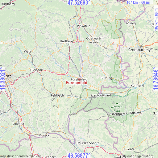
Fürstenfeld GPS coordinates[2]
47° 3' 0" North, 16° 4' 59.988" East
| Map corner | latitude | longitude |
|---|---|---|
| Upper-left | 47.52693°, | 15.38021° |
| Center: | 47.05°, | 16.08333° |
| Lower-right: | 46.56877°, | 16.78646° |
| Map W x H: | 106.5×106.5 km | = 66.2×66.2mi |
| max Lat: | 48.98333° ⇑82.2% North |
| Fürstenfeld: | 47.05° |
| min Lat: | ⇓17.8% South 46.48841° |
| min Long | Fürstenfeld | max Long |
| 9.57802° | 16.08333° | 17.1° |
| W 82.4%⇐ | ⇒17.6% E |
Elevation
Elevation of Fürstenfeld is 255 m = 837 ft, and this is 250.5 m = 822 ft below average elevation for this country.
| Max E: |
2140 m = 7021 ft | 83.6% |
| Avg. | 505.5 m = 1658 ft | |
| Fürstenfeld | 255 m = 837 ft | |
Min E: |
118 m = 387 ft | 16.4% |
See also: Austria elevation on elevation.city.
Geographical zone
Fürstenfeld is located in North temperate zone (between Tropic of Cancer and the Arctic Circle). Distance of this North polar circle is 2169.7 km =1348.2 mi to North.| Distance of | km | miles | from Fürstenfeld |
|---|---|---|---|
| North Pole | 4775.6 | 2967.4 | to North |
| Arctic Circle | 2169.7 | 1348.2 | to North |
| Tropic Cancer | 2625.6 | 1631.5 | to South |
| Equator | 5231.5 | 3250.7 | to South |


Nearby cities:
15 places around Fürstenfeld: (largest is in red/bold)
• Altenmarkt bei Fürstenfeld
3.2 km =2 mi,  304°
304°
• Bad Blumau
7.8 km =4.8 mi,  341°
341°
• Deutsch Kaltenbrunn
6.1 km =3.8 mi,  36°
36°
• Dietersdorf bei Fürstenfeld
3.3 km =2.1 mi,  159°
159°
• Grosswilfersdorf
8.4 km =5.2 mi, 296°
• Königsdorf
8.4 km =5.2 mi,  131°
131°
• Limbach im Burgenland
6.6 km =4.1 mi,  73°
73°
• Loipersdorf bei Fürstenfeld
5.7 km =3.5 mi,  167°
167°
• Neusiedl bei Güssing
9.4 km =5.8 mi,  53°
53°
• Rohrbrunn
8.6 km =5.3 mi,  16°
16°
• Rudersdorf
2.5 km =1.6 mi,  90°
90°
• Stein
5.8 km =3.6 mi,  177°
177°
• Söchau
5.4 km =3.4 mi,  249°
249°
• Unterlamm
8.3 km =5.2 mi,  190°
190°
• Übersbach
3.7 km =2.3 mi,  215°
215°
Sources, notices
• [Note1] Compared only with cities in Austria existing in our database
• [Src1] Map data: © OpenStreetMap contributors (CC-BY-SA)
• [Src2] Other city data from geonames.org with taken over terms of usage.
• [Src3] Geographical zone / Annual Mean Temperature by Robert A. Rohde @ Wikipedia
