Trössing geodata
Trössing (Styria) is a seat of a third-order administrative division; located in Austria in Europe/Vienna (GMT+2) time zone. With population of 257 people, there are 2799 cities with bigger population in this country. Compared to other cities in Austria, 91.1% of cities are located further ↑North; 75.1% of cities are located further ←West and 81.5% of cities have higher elevation than Trössing. Note1
Administrative division(s):
- Level 1: Styria
- Level 2: Politischer Bezirk Südoststeiermark
- Level 3: Gnas


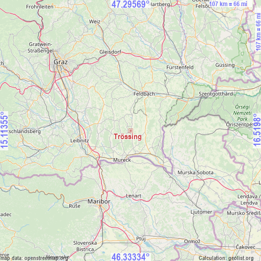
Trössing GPS coordinates[2]
46° 49' 0.012" North, 15° 49' 0.012" East
| Map corner | latitude | longitude |
|---|---|---|
| Upper-left | 47.29569°, | 15.11355° |
| Center: | 46.81667°, | 15.81667° |
| Lower-right: | 46.33334°, | 16.5198° |
| Map W x H: | 107×107 km | = 66.5×66.5mi |
| max Lat: | 48.98333° ⇑91.1% North |
| Trössing: | 46.81667° |
| min Lat: | ⇓8.9% South 46.48841° |
| min Long | Trössing | max Long |
| 9.57802° | 15.81667° | 17.1° |
| W 75.1%⇐ | ⇒24.9% E |
Elevation
Elevation of Trössing is 268 m = 879 ft, and this is 237.5 m = 779 ft below average elevation for this country.
| Max E: |
2140 m = 7021 ft | 81.5% |
| Avg. | 505.5 m = 1658 ft | |
| Trössing | 268 m = 879 ft | |
Min E: |
118 m = 387 ft | 18.5% |
See also: Austria elevation on elevation.city.
Geographical zone
Trössing is located in North temperate zone (between Tropic of Cancer and the Arctic Circle). Distance of this North polar circle is 2195.6 km =1364.3 mi to North.| Distance of | km | miles | from Trössing |
|---|---|---|---|
| North Pole | 4801.5 | 2983.5 | to North |
| Arctic Circle | 2195.6 | 1364.3 | to North |
| Tropic Cancer | 2599.6 | 1615.3 | to South |
| Equator | 5205.5 | 3234.5 | to South |


Nearby cities:
15 places around Trössing: (largest is in red/bold)
• Bierbaum am Auersbach
2.3 km =1.4 mi,  307°
307°
• Burgfried
7.1 km =4.4 mi,  10°
10°
• Deutsch Goritz
7.4 km =4.6 mi,  172°
172°
• Dietersdorf am Gnasbach
0.9 km =0.6 mi,  204°
204°
• Gnas
6.3 km =3.9 mi, 5°
• Grabersdorf
3 km =1.9 mi, 11°
• Jagerberg
7.3 km =4.5 mi,  304°
304°
• Krusdorf
4.2 km =2.6 mi,  52°
52°
• Merkendorf
8 km =5 mi,  55°
55°
• Poppendorf
5.3 km =3.3 mi,  34°
34°
• Raning
3.7 km =2.3 mi,  0°
0°
• Sankt Peter am Ottersbach
4.9 km =3 mi,  244°
244°
• Stainz bei Straden
5.8 km =3.6 mi,  81°
81°
• Straden
4 km =2.5 mi,  102°
102°
• Unterauersbach
6.5 km =4 mi,  327°
327°
Sources, notices
• [Note1] Compared only with cities in Austria existing in our database
• [Src1] Map data: © OpenStreetMap contributors (CC-BY-SA)
• [Src2] Other city data from geonames.org with taken over terms of usage.
• [Src3] Geographical zone / Annual Mean Temperature by Robert A. Rohde @ Wikipedia
