Poppendorf geodata
Poppendorf (Styria) is a seat of a third-order administrative division; located in Austria in Europe/Vienna (GMT+2) time zone. With population of 281 people, there are 2771 cities with bigger population in this country. Compared to other cities in Austria, 89.4% of cities are located further ↑North; 76.2% of cities are located further ←West and 74.2% of cities have higher elevation than Poppendorf. Note1
Administrative division(s):
- Level 1: Styria
- Level 2: Politischer Bezirk Südoststeiermark
- Level 3: Gnas


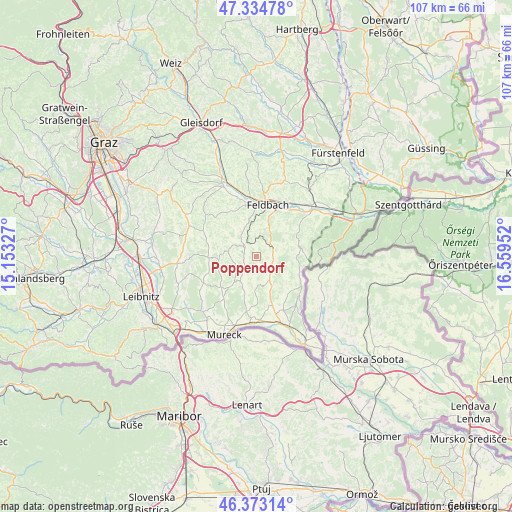
Poppendorf GPS coordinates[2]
46° 51' 21.996" North, 15° 51' 23.004" East
| Map corner | latitude | longitude |
|---|---|---|
| Upper-left | 47.33478°, | 15.15327° |
| Center: | 46.85611°, | 15.85639° |
| Lower-right: | 46.37314°, | 16.55952° |
| Map W x H: | 106.9×106.9 km | = 66.4×66.4mi |
| max Lat: | 48.98333° ⇑89.4% North |
| Poppendorf: | 46.85611° |
| min Lat: | ⇓10.6% South 46.48841° |
| min Long | Poppendorf | max Long |
| 9.57802° | 15.85639° | 17.1° |
| W 76.2%⇐ | ⇒23.8% E |
Elevation
Elevation of Poppendorf is 308 m = 1010 ft, and this is 197.5 m = 648 ft below average elevation for this country.
| Max E: |
2140 m = 7021 ft | 74.2% |
| Avg. | 505.5 m = 1658 ft | |
| Poppendorf | 308 m = 1010 ft | |
Min E: |
118 m = 387 ft | 25.8% |
See also: Austria elevation on elevation.city.
Geographical zone
Poppendorf is located in North temperate zone (between Tropic of Cancer and the Arctic Circle). Distance of this North polar circle is 2191.3 km =1361.6 mi to North.| Distance of | km | miles | from Poppendorf |
|---|---|---|---|
| North Pole | 4797.2 | 2980.8 | to North |
| Arctic Circle | 2191.3 | 1361.6 | to North |
| Tropic Cancer | 2604 | 1618.1 | to South |
| Equator | 5209.9 | 3237.3 | to South |


Nearby cities:
15 places around Poppendorf: (largest is in red/bold)
• Bad Gleichenberg
4.5 km =2.8 mi,  61°
61°
• Bairisch Kölldorf
6 km =3.7 mi,  78°
78°
• Bierbaum am Auersbach
5.7 km =3.5 mi,  238°
238°
• Burgfried
3.1 km =1.9 mi,  325°
325°
• Gleichenberg Dorf
4.5 km =2.8 mi,  47°
47°
• Gnas
3 km =1.9 mi,  308°
308°
• Grabersdorf
2.8 km =1.7 mi, 238°
• Krusdorf
1.9 km =1.2 mi,  169°
169°
• Maierdorf
4.1 km =2.5 mi,  352°
352°
• Merkendorf
3.6 km =2.2 mi,  88°
88°
• Raning
3.1 km =1.9 mi,  257°
257°
• Stainz bei Straden
4.5 km =2.8 mi,  142°
142°
• Straden
5.3 km =3.3 mi, 170°
• Trautmannsdorf in Oststeiermark
3 km =1.9 mi, 45°
• Trössing
5.3 km =3.3 mi,  214°
214°
Sources, notices
• [Note1] Compared only with cities in Austria existing in our database
• [Src1] Map data: © OpenStreetMap contributors (CC-BY-SA)
• [Src2] Other city data from geonames.org with taken over terms of usage.
• [Src3] Geographical zone / Annual Mean Temperature by Robert A. Rohde @ Wikipedia
