Burgfried geodata
Burgfried (Styria) is a populated place; located in Austria in Europe/Vienna (GMT+2) time zone. With population of 523 people, there are 2418 cities with bigger population in this country. Compared to other cities in Austria, 88.5% of cities are located further ↑North; 75.7% of cities are located further ←West and 68.8% of cities have higher elevation than Burgfried. Note1
Administrative division(s):
- Level 1: Styria
- Level 2: Politischer Bezirk Südoststeiermark
- Level 3: Gnas


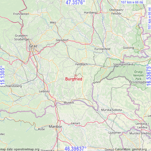
Burgfried GPS coordinates[2]
46° 52' 44.904" North, 15° 50' 1.032" East
| Map corner | latitude | longitude |
|---|---|---|
| Upper-left | 47.3576°, | 15.1305° |
| Center: | 46.87914°, | 15.83362° |
| Lower-right: | 46.39637°, | 16.53675° |
| Map W x H: | 106.9×106.9 km | = 66.4×66.4mi |
| max Lat: | 48.98333° ⇑88.5% North |
| Burgfried: | 46.87914° |
| min Lat: | ⇓11.5% South 46.48841° |
| min Long | Burgfried | max Long |
| 9.57802° | 15.83362° | 17.1° |
| W 75.7%⇐ | ⇒24.3% E |
Elevation
Elevation of Burgfried is 335 m = 1099 ft, and this is 170.5 m = 559 ft below average elevation for this country.
| Max E: |
2140 m = 7021 ft | 68.8% |
| Avg. | 505.5 m = 1658 ft | |
| Burgfried | 335 m = 1099 ft | |
Min E: |
118 m = 387 ft | 31.2% |
See also: Austria elevation on elevation.city.
Geographical zone
Burgfried is located in North temperate zone (between Tropic of Cancer and the Arctic Circle). Distance of this North polar circle is 2188.7 km =1360 mi to North.| Distance of | km | miles | from Burgfried |
|---|---|---|---|
| North Pole | 4794.6 | 2979.2 | to North |
| Arctic Circle | 2188.7 | 1360 | to North |
| Tropic Cancer | 2606.6 | 1619.7 | to South |
| Equator | 5212.5 | 3238.9 | to South |


Nearby cities:
15 places around Burgfried: (largest is in red/bold)
• Bad Gleichenberg
5.7 km =3.5 mi,  93°
93°
• Baumgarten bei Gnas
6.6 km =4.1 mi,  309°
309°
• Bierbaum am Auersbach
6.3 km =3.9 mi,  209°
209°
• Gleichenberg Dorf
5.1 km =3.2 mi,  84°
84°
• Gnas
0.9 km =0.6 mi,  223°
223°
• Grabersdorf
4.1 km =2.5 mi,  189°
189°
• Kohlberg
4.5 km =2.8 mi,  301°
301°
• Krusdorf
4.9 km =3 mi,  154°
154°
• Maierdorf
1.9 km =1.2 mi,  39°
39°
• Merkendorf
5.9 km =3.7 mi,  114°
114°
• Perlsdorf
4.1 km =2.5 mi,  338°
338°
• Poppendorf
3.1 km =1.9 mi, 145°
• Raning
3.5 km =2.2 mi,  201°
201°
• Trautmannsdorf in Oststeiermark
3.9 km =2.4 mi,  96°
96°
• Unterauersbach
5 km =3.1 mi,  252°
252°
Sources, notices
• [Note1] Compared only with cities in Austria existing in our database
• [Src1] Map data: © OpenStreetMap contributors (CC-BY-SA)
• [Src2] Other city data from geonames.org with taken over terms of usage.
• [Src3] Geographical zone / Annual Mean Temperature by Robert A. Rohde @ Wikipedia
