Theresienfeld geodata
Theresienfeld (Lower Austria) is a seat of a third-order administrative division; located in Austria in Europe/Vienna (GMT+2) time zone. With population of 3,485 people, there are 312 cities with bigger population in this country. Compared to other cities in Austria, 58.7% of cities are located further ↓South; 87% of cities are located further ←West and 78.7% of cities have higher elevation than Theresienfeld. Note1
Administrative division(s):
- Level 1: Lower Austria
- Level 2: Politischer Bezirk Wiener Neustadt
- Level 3: Theresienfeld


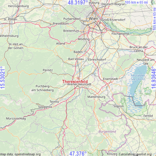
Theresienfeld GPS coordinates[2]
47° 51' 0" North, 16° 13' 59.988" East
| Map corner | latitude | longitude |
|---|---|---|
| Upper-left | 48.3197°, | 15.53021° |
| Center: | 47.85°, | 16.23333° |
| Lower-right: | 47.376°, | 16.93646° |
| Map W x H: | 104.9×104.9 km | = 65.2×65.2mi |
| max Lat: | 48.98333° ⇑41.3% North |
| Theresienfeld: | 47.85° |
| min Lat: | ⇓58.7% South 46.48841° |
| min Long | Theresienfeld | max Long |
| 9.57802° | 16.23333° | 17.1° |
| W 87%⇐ | ⇒13% E |
Elevation
Elevation of Theresienfeld is 280 m = 919 ft, and this is 225.5 m = 740 ft below average elevation for this country.
| Max E: |
2140 m = 7021 ft | 78.7% |
| Avg. | 505.5 m = 1658 ft | |
| Theresienfeld | 280 m = 919 ft | |
Min E: |
118 m = 387 ft | 21.3% |
See also: Austria elevation on elevation.city.
Geographical zone
Theresienfeld is located in North temperate zone (between Tropic of Cancer and the Arctic Circle). Distance of this North polar circle is 2080.8 km =1292.9 mi to North.| Distance of | km | miles | from Theresienfeld |
|---|---|---|---|
| North Pole | 4686.6 | 2912.1 | to North |
| Arctic Circle | 2080.8 | 1292.9 | to North |
| Tropic Cancer | 2714.5 | 1686.7 | to South |
| Equator | 5320.4 | 3305.9 | to South |


Nearby cities:
15 places around Theresienfeld: (largest is in red/bold)
• Bad Fischau
5.4 km =3.4 mi,  247°
247°
• Brunn an der Schneebergbahn
6.2 km =3.9 mi,  242°
242°
• Eggendorf
6.7 km =4.2 mi,  82°
82°
• Felixdorf
3.6 km =2.2 mi,  10°
10°
• Katzelsdorf
8.2 km =5.1 mi,  160°
160°
• Lichtenwörth
5.5 km =3.4 mi,  117°
117°
• Markt Piesting
8.5 km =5.3 mi,  287°
287°
• Matzendorf
4.8 km =3 mi,  342°
342°
• Neudörfl
7.6 km =4.7 mi,  141°
141°
• Sollenau
5.5 km =3.4 mi, 11°
• Steinabrückl
3.2 km =2 mi,  315°
315°
• Weikersdorf am Steinfelde
8.3 km =5.2 mi,  233°
233°
• Wiener Neustadt
5 km =3.1 mi,  181°
181°
• Wöllersdorf
4.9 km =3 mi, 289°
• Zillingdorf
7.5 km =4.7 mi,  90°
90°
Sources, notices
• [Note1] Compared only with cities in Austria existing in our database
• [Src1] Map data: © OpenStreetMap contributors (CC-BY-SA)
• [Src2] Other city data from geonames.org with taken over terms of usage.
• [Src3] Geographical zone / Annual Mean Temperature by Robert A. Rohde @ Wikipedia
