Tarrenz geodata
Tarrenz (Tyrol) is a seat of a third-order administrative division; located in Austria in Europe/Vienna (GMT+2) time zone. With population of 1,894 people, there are 654 cities with bigger population in this country. Compared to other cities in Austria, 68.3% of cities are located further ↑North; 94.4% of cities are located further →East and 86.1% of cities have lower elevation than Tarrenz. Note1


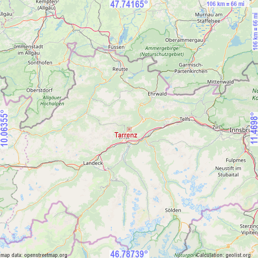
Tarrenz GPS coordinates[2]
47° 16' 0.012" North, 10° 46' 0.012" East
| Map corner | latitude | longitude |
|---|---|---|
| Upper-left | 47.74165°, | 10.06355° |
| Center: | 47.26667°, | 10.76667° |
| Lower-right: | 46.78739°, | 11.4698° |
| Map W x H: | 106.1×106.1 km | = 65.9×65.9mi |
| max Lat: | 48.98333° ⇑68.3% North |
| Tarrenz: | 47.26667° |
| min Lat: | ⇓31.7% South 46.48841° |
| min Long | Tarrenz | max Long |
| 9.57802° | 10.76667° | 17.1° |
| W 5.6%⇐ | ⇒94.4% E |
Elevation
Elevation of Tarrenz is 816 m = 2677 ft, and this is 310.5 m = 1019 ft above average elevation for this country.
| Max E: |
2140 m = 7021 ft | 13.9% |
| Tarrenz | 816 m 2677 ft | |
| Avg. | 505.5 m = 1658 ft | |
Min E: |
118 m = 387 ft | 86.1% |
See also: Austria elevation on elevation.city.
Geographical zone
Tarrenz is located in North temperate zone (between Tropic of Cancer and the Arctic Circle). Distance of this North polar circle is 2145.6 km =1333.2 mi to North.| Distance of | km | miles | from Tarrenz |
|---|---|---|---|
| North Pole | 4751.5 | 2952.4 | to North |
| Arctic Circle | 2145.6 | 1333.2 | to North |
| Tropic Cancer | 2649.6 | 1646.4 | to South |
| Equator | 5255.6 | 3265.7 | to South |


Nearby cities:
15 places around Tarrenz: (largest is in red/bold)
• Arzl im Pitztal
6.6 km =4.1 mi,  182°
182°
• Haiming
9 km =5.6 mi,  101°
101°
• Imst
3.1 km =1.9 mi,  220°
220°
• Imsterberg
8.7 km =5.4 mi, 217°
• Karres
5.7 km =3.5 mi,  167°
167°
• Karrösten
4.6 km =2.9 mi, 180°
• Mils bei Imst
9.7 km =6 mi,  225°
225°
• Namlos
11.9 km =7.4 mi,  320°
320°
• Nassereith
7.5 km =4.7 mi,  42°
42°
• Roppen
6.7 km =4.2 mi,  145°
145°
• Sautens
10.6 km =6.6 mi,  134°
134°
• Schönwies
11.3 km =7 mi, 226°
• Wald
7.4 km =4.6 mi, 180°
• Wenns
11.4 km =7.1 mi,  192°
192°
• Ötztal-Bahnhof
7.3 km =4.5 mi,  120°
120°
Sources, notices
• [Note1] Compared only with cities in Austria existing in our database
• [Src1] Map data: © OpenStreetMap contributors (CC-BY-SA)
• [Src2] Other city data from geonames.org with taken over terms of usage.
• [Src3] Geographical zone / Annual Mean Temperature by Robert A. Rohde @ Wikipedia
