Ötztal-Bahnhof geodata
Ötztal-Bahnhof (Tyrol) is a populated place; located in Austria in Europe/Vienna (GMT+2) time zone. With population of 1,534 people, there are 823 cities with bigger population in this country. Compared to other cities in Austria, 70.3% of cities are located further ↑North; 94.2% of cities are located further →East and 80.2% of cities have lower elevation than Ötztal-Bahnhof. Note1


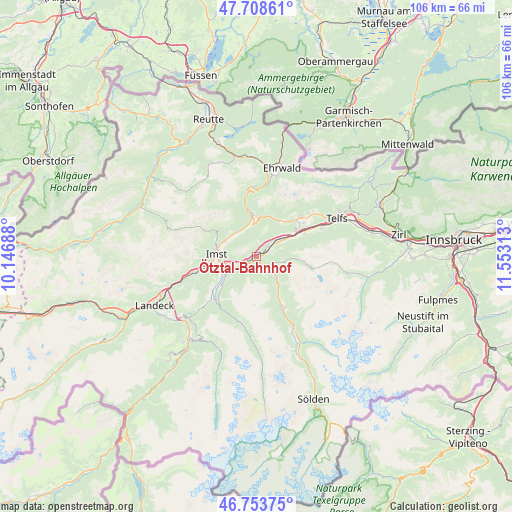
Ötztal-Bahnhof GPS coordinates[2]
47° 13' 59.988" North, 10° 51' 0" East
| Map corner | latitude | longitude |
|---|---|---|
| Upper-left | 47.70861°, | 10.14688° |
| Center: | 47.23333°, | 10.85° |
| Lower-right: | 46.75375°, | 11.55313° |
| Map W x H: | 106.2×106.2 km | = 66×66mi |
| max Lat: | 48.98333° ⇑70.3% North |
| Ötztal-Bahnhof: | 47.23333° |
| min Lat: | ⇓29.7% South 46.48841° |
| min Long | Ötztal-Bahnhof | max Long |
| 9.57802° | 10.85° | 17.1° |
| W 5.8%⇐ | ⇒94.2% E |
Elevation
Elevation of Ötztal-Bahnhof is 722 m = 2369 ft, and this is 216.5 m = 710 ft above average elevation for this country.
| Max E: |
2140 m = 7021 ft | 19.8% |
| Ötztal-Bahnhof | 722 m 2369 ft | |
| Avg. | 505.5 m = 1658 ft | |
Min E: |
118 m = 387 ft | 80.2% |
See also: Austria elevation on elevation.city.
Geographical zone
Ötztal-Bahnhof is located in North temperate zone (between Tropic of Cancer and the Arctic Circle). Distance of this North polar circle is 2149.3 km =1335.5 mi to North.| Distance of | km | miles | from Ötztal-Bahnhof |
|---|---|---|---|
| North Pole | 4755.2 | 2954.7 | to North |
| Arctic Circle | 2149.3 | 1335.5 | to North |
| Tropic Cancer | 2645.9 | 1644.1 | to South |
| Equator | 5251.9 | 3263.4 | to South |


Nearby cities:
15 places around Ötztal-Bahnhof: (largest is in red/bold)
• Arzl im Pitztal
7.2 km =4.5 mi,  246°
246°
• Haiming
3.1 km =1.9 mi,  53°
53°
• Imst
8.4 km =5.2 mi,  278°
278°
• Karres
5.4 km =3.4 mi, 249°
• Karrösten
6.4 km =4 mi,  262°
262°
• Mötz
9.4 km =5.8 mi, 53°
• Nassereith
9.4 km =5.8 mi,  352°
352°
• Obsteig
9.7 km =6 mi,  40°
40°
• Oetz
5.3 km =3.3 mi,  134°
134°
• Roppen
3.1 km =1.9 mi,  233°
233°
• Sautens
3.9 km =2.4 mi,  161°
161°
• Silz
7.3 km =4.5 mi,  59°
59°
• Tarrenz
7.3 km =4.5 mi,  300°
300°
• Tumpen
8.3 km =5.2 mi,  152°
152°
• Wald
7.3 km =4.5 mi,  239°
239°
Sources, notices
• [Note1] Compared only with cities in Austria existing in our database
• [Src1] Map data: © OpenStreetMap contributors (CC-BY-SA)
• [Src2] Other city data from geonames.org with taken over terms of usage.
• [Src3] Geographical zone / Annual Mean Temperature by Robert A. Rohde @ Wikipedia
