Sipbachzell geodata
Sipbachzell (Upper Austria) is a populated place; located in Austria in Europe/Vienna (GMT+2) time zone. With population of 829 people, there are 1558 cities with bigger population in this country. Compared to other cities in Austria, 72.5% of cities are located further ↓South; 62.6% of cities are located further →East and 63.2% of cities have higher elevation than Sipbachzell. Note1


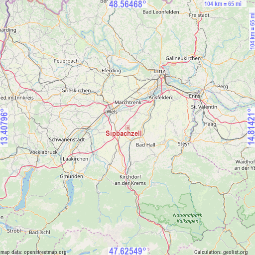
Sipbachzell GPS coordinates[2]
48° 5' 50.028" North, 14° 6' 39.888" East
| Map corner | latitude | longitude |
|---|---|---|
| Upper-left | 48.56468°, | 13.40796° |
| Center: | 48.09723°, | 14.11108° |
| Lower-right: | 47.62549°, | 14.81421° |
| Map W x H: | 104.4×104.4 km | = 64.9×64.9mi |
| max Lat: | 48.98333° ⇑27.5% North |
| Sipbachzell: | 48.09723° |
| min Lat: | ⇓72.5% South 46.48841° |
| min Long | Sipbachzell | max Long |
| 9.57802° | 14.11108° | 17.1° |
| W 37.4%⇐ | ⇒62.6% E |
Elevation
Elevation of Sipbachzell is 362 m = 1188 ft, and this is 143.5 m = 471 ft below average elevation for this country.
| Max E: |
2140 m = 7021 ft | 63.2% |
| Avg. | 505.5 m = 1658 ft | |
| Sipbachzell | 362 m = 1188 ft | |
Min E: |
118 m = 387 ft | 36.8% |
See also: Austria elevation on elevation.city.
Geographical zone
Sipbachzell is located in North temperate zone (between Tropic of Cancer and the Arctic Circle). Distance of this North polar circle is 2053.3 km =1275.9 mi to North.| Distance of | km | miles | from Sipbachzell |
|---|---|---|---|
| North Pole | 4659.2 | 2895.1 | to North |
| Arctic Circle | 2053.3 | 1275.9 | to North |
| Tropic Cancer | 2742 | 1703.8 | to South |
| Equator | 5347.9 | 3323 | to South |


Nearby cities:
15 places around Sipbachzell: (largest is in red/bold)
• Allhaming
7.5 km =4.7 mi,  35°
35°
• Bergern
7.8 km =4.8 mi,  0°
0°
• Eggendorf im Traunkreis
4.5 km =2.8 mi,  33°
33°
• Hochpoint
8.9 km =5.5 mi,  322°
322°
• Kematen an der Krems
6.4 km =4 mi,  75°
75°
• Kremsmünster
5.1 km =3.2 mi,  164°
164°
• Piberbach
8.8 km =5.5 mi, 76°
• Ried im Traunkreis
8.4 km =5.2 mi,  198°
198°
• Rohr im Kremstal
6.9 km =4.3 mi,  117°
117°
• Sattledt
4.9 km =3 mi,  237°
237°
• Schafwiesen
8.4 km =5.2 mi,  336°
336°
• Schleissheim
7.5 km =4.7 mi, 339°
• Steinhaus
7.2 km =4.5 mi,  287°
287°
• Thalheim bei Wels
8.2 km =5.1 mi, 315°
• Weisskirchen an der Traun
7.3 km =4.5 mi,  7°
7°
Sources, notices
• [Note1] Compared only with cities in Austria existing in our database
• [Src1] Map data: © OpenStreetMap contributors (CC-BY-SA)
• [Src2] Other city data from geonames.org with taken over terms of usage.
• [Src3] Geographical zone / Annual Mean Temperature by Robert A. Rohde @ Wikipedia
