Sillian geodata
Sillian (Tyrol) is a seat of a third-order administrative division; located in Austria in Europe/Vienna (GMT+2) time zone. With population of 1,604 people, there are 780 cities with bigger population in this country. Compared to other cities in Austria, 93.4% of cities are located further ↑North; 86.6% of cities are located further →East and 98.2% of cities have lower elevation than Sillian. Note1


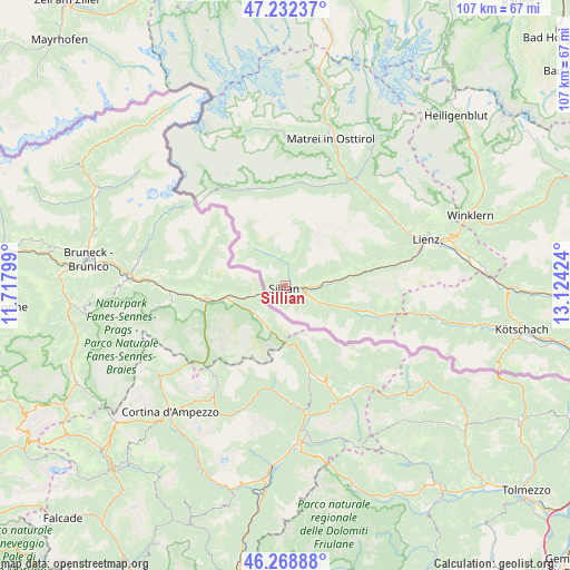
Sillian GPS coordinates[2]
46° 45' 10.008" North, 12° 25' 15.996" East
| Map corner | latitude | longitude |
|---|---|---|
| Upper-left | 47.23237°, | 11.71799° |
| Center: | 46.75278°, | 12.42111° |
| Lower-right: | 46.26888°, | 13.12424° |
| Map W x H: | 107.1×107.1 km | = 66.5×66.5mi |
| max Lat: | 48.98333° ⇑93.4% North |
| Sillian: | 46.75278° |
| min Lat: | ⇓6.6% South 46.48841° |
| min Long | Sillian | max Long |
| 9.57802° | 12.42111° | 17.1° |
| W 13.4%⇐ | ⇒86.6% E |
Elevation
Elevation of Sillian is 1218 m = 3996 ft, and this is 712.5 m = 2338 ft above average elevation for this country.
| Max E: |
2140 m = 7021 ft | 1.8% |
| Sillian | 1218 m 3996 ft | |
| Avg. | 505.5 m = 1658 ft | |
Min E: |
118 m = 387 ft | 98.2% |
See also: Austria elevation on elevation.city.
Geographical zone
Sillian is located in North temperate zone (between Tropic of Cancer and the Arctic Circle). Distance of this North polar circle is 2202.8 km =1368.8 mi to North.| Distance of | km | miles | from Sillian |
|---|---|---|---|
| North Pole | 4808.6 | 2987.9 | to North |
| Arctic Circle | 2202.8 | 1368.8 | to North |
| Tropic Cancer | 2592.5 | 1610.9 | to South |
| Equator | 5198.4 | 3230.1 | to South |


Nearby cities:
15 places around Sillian: (largest is in red/bold)
• Abfaltersbach
8.2 km =5.1 mi,  86°
86°
• Anras
10.9 km =6.8 mi,  77°
77°
• Assling
17.1 km =10.6 mi, 77°
• Außervillgraten
3.9 km =2.4 mi,  11°
11°
• Heinfels
2.2 km =1.4 mi,  97°
97°
• Hopfgarten in Defereggen
20.5 km =12.7 mi,  25°
25°
• Innervillgraten
7.5 km =4.7 mi,  331°
331°
• Kartitsch
6.6 km =4.1 mi,  113°
113°
• Obertilliach
15.5 km =9.6 mi, 107°
• Panzendorf
3.5 km =2.2 mi, 86°
• Sankt Jakob in Defereggen
19.8 km =12.3 mi,  339°
339°
• Sankt Veit in Defereggen
19.4 km =12.1 mi,  1°
1°
• Schlaiten
22.6 km =14 mi,  51°
51°
• Strassen
4.8 km =3 mi, 88°
• Untertilliach
20.3 km =12.6 mi, 105°
Sources, notices
• [Note1] Compared only with cities in Austria existing in our database
• [Src1] Map data: © OpenStreetMap contributors (CC-BY-SA)
• [Src2] Other city data from geonames.org with taken over terms of usage.
• [Src3] Geographical zone / Annual Mean Temperature by Robert A. Rohde @ Wikipedia
