Schlaiten geodata
Schlaiten (Tyrol) is a seat of a third-order administrative division; located in Austria in Europe/Vienna (GMT+2) time zone. With population of 474 people, there are 2536 cities with bigger population in this country. Compared to other cities in Austria, 88.5% of cities are located further ↑North; 85.4% of cities are located further →East and 89.5% of cities have lower elevation than Schlaiten. Note1


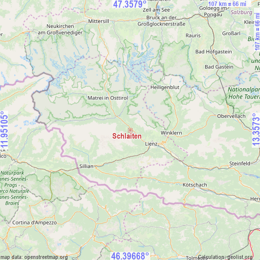
Schlaiten GPS coordinates[2]
46° 52' 45.984" North, 12° 39' 15.012" East
| Map corner | latitude | longitude |
|---|---|---|
| Upper-left | 47.3579°, | 11.95105° |
| Center: | 46.87944°, | 12.65417° |
| Lower-right: | 46.39668°, | 13.3573° |
| Map W x H: | 106.9×106.9 km | = 66.4×66.4mi |
| max Lat: | 48.98333° ⇑88.5% North |
| Schlaiten: | 46.87944° |
| min Lat: | ⇓11.5% South 46.48841° |
| min Long | Schlaiten | max Long |
| 9.57802° | 12.65417° | 17.1° |
| W 14.6%⇐ | ⇒85.4% E |
Elevation
Elevation of Schlaiten is 867 m = 2844 ft, and this is 361.5 m = 1186 ft above average elevation for this country.
| Max E: |
2140 m = 7021 ft | 10.5% |
| Schlaiten | 867 m 2844 ft | |
| Avg. | 505.5 m = 1658 ft | |
Min E: |
118 m = 387 ft | 89.5% |
See also: Austria elevation on elevation.city.
Geographical zone
Schlaiten is located in North temperate zone (between Tropic of Cancer and the Arctic Circle). Distance of this North polar circle is 2188.7 km =1360 mi to North.| Distance of | km | miles | from Schlaiten |
|---|---|---|---|
| North Pole | 4794.6 | 2979.2 | to North |
| Arctic Circle | 2188.7 | 1360 | to North |
| Tropic Cancer | 2606.6 | 1619.7 | to South |
| Equator | 5212.5 | 3238.9 | to South |


Nearby cities:
15 places around Schlaiten: (largest is in red/bold)
• Ainet
3.1 km =1.9 mi,  118°
118°
• Amlach
10.9 km =6.8 mi,  130°
130°
• Anras
13.7 km =8.5 mi,  211°
211°
• Assling
10.4 km =6.5 mi,  186°
186°
• Debant
13.4 km =8.3 mi,  112°
112°
• Dölsach
15.6 km =9.7 mi, 111°
• Hopfgarten in Defereggen
10 km =6.2 mi,  296°
296°
• Kals am Großglockner
13.7 km =8.5 mi,  357°
357°
• Leisach
10.3 km =6.4 mi,  136°
136°
• Lienz
10.4 km =6.5 mi, 122°
• Matrei in Osttirol
16.2 km =10.1 mi,  325°
325°
• Nußdorf
12.2 km =7.6 mi, 114°
• Oberlienz
6.9 km =4.3 mi, 121°
• Thurn
9.3 km =5.8 mi, 110°
• Tristach
12.5 km =7.8 mi, 124°
Sources, notices
• [Note1] Compared only with cities in Austria existing in our database
• [Src1] Map data: © OpenStreetMap contributors (CC-BY-SA)
• [Src2] Other city data from geonames.org with taken over terms of usage.
• [Src3] Geographical zone / Annual Mean Temperature by Robert A. Rohde @ Wikipedia
