Kartitsch geodata
Kartitsch (Tyrol) is a seat of a third-order administrative division; located in Austria in Europe/Vienna (GMT+2) time zone. With population of 756 people, there are 1716 cities with bigger population in this country. Compared to other cities in Austria, 94.3% of cities are located further ↑North; 86.1% of cities are located further →East and 99.7% of cities have lower elevation than Kartitsch. Note1


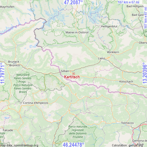
Kartitsch GPS coordinates[2]
46° 43' 44.004" North, 12° 30' 2.988" East
| Map corner | latitude | longitude |
|---|---|---|
| Upper-left | 47.2087°, | 11.79771° |
| Center: | 46.72889°, | 12.50083° |
| Lower-right: | 46.24478°, | 13.20396° |
| Map W x H: | 107.2×107.2 km | = 66.6×66.6mi |
| max Lat: | 48.98333° ⇑94.3% North |
| Kartitsch: | 46.72889° |
| min Lat: | ⇓5.7% South 46.48841° |
| min Long | Kartitsch | max Long |
| 9.57802° | 12.50083° | 17.1° |
| W 13.9%⇐ | ⇒86.1% E |
Elevation
Elevation of Kartitsch is 1485 m = 4872 ft, and this is 979.5 m = 3214 ft above average elevation for this country.
| Max E: |
2140 m = 7021 ft | 0.3% |
| Kartitsch | 1485 m 4872 ft | |
| Avg. | 505.5 m = 1658 ft | |
Min E: |
118 m = 387 ft | 99.7% |
See also: Austria elevation on elevation.city.
Geographical zone
Kartitsch is located in North temperate zone (between Tropic of Cancer and the Arctic Circle). Distance of this North polar circle is 2205.4 km =1370.4 mi to North.| Distance of | km | miles | from Kartitsch |
|---|---|---|---|
| North Pole | 4811.3 | 2989.6 | to North |
| Arctic Circle | 2205.4 | 1370.4 | to North |
| Tropic Cancer | 2589.8 | 1609.2 | to South |
| Equator | 5195.8 | 3228.5 | to South |


Nearby cities:
15 places around Kartitsch: (largest is in red/bold)
• Abfaltersbach
3.8 km =2.4 mi,  33°
33°
• Ainet
21 km =13 mi,  43°
43°
• Anras
6.8 km =4.2 mi, 42°
• Assling
12.4 km =7.7 mi,  58°
58°
• Außervillgraten
8.4 km =5.2 mi,  320°
320°
• Heinfels
4.5 km =2.8 mi,  301°
301°
• Hopfgarten in Defereggen
21.3 km =13.2 mi,  7°
7°
• Innervillgraten
13.3 km =8.3 mi,  313°
313°
• Leisach
21 km =13 mi, 63°
• Obertilliach
8.9 km =5.5 mi,  103°
103°
• Panzendorf
3.9 km =2.4 mi, 317°
• Schlaiten
20.4 km =12.7 mi, 34°
• Sillian
6.6 km =4.1 mi,  293°
293°
• Strassen
3.1 km =1.9 mi,  335°
335°
• Untertilliach
13.8 km =8.6 mi, 101°
Sources, notices
• [Note1] Compared only with cities in Austria existing in our database
• [Src1] Map data: © OpenStreetMap contributors (CC-BY-SA)
• [Src2] Other city data from geonames.org with taken over terms of usage.
• [Src3] Geographical zone / Annual Mean Temperature by Robert A. Rohde @ Wikipedia
