Siebenhaus geodata
Siebenhaus (Lower Austria) is a populated place; located in Austria in Europe/Vienna (GMT+2) time zone. With population of 639 people, there are 2012 cities with bigger population in this country. Compared to other cities in Austria, 62.5% of cities are located further ↓South; 86.7% of cities are located further ←West and 82.8% of cities have higher elevation than Siebenhaus. Note1
Administrative division(s):
- Level 1: Lower Austria
- Level 2: Politischer Bezirk Baden
- Level 3: Schönau an der Triesting


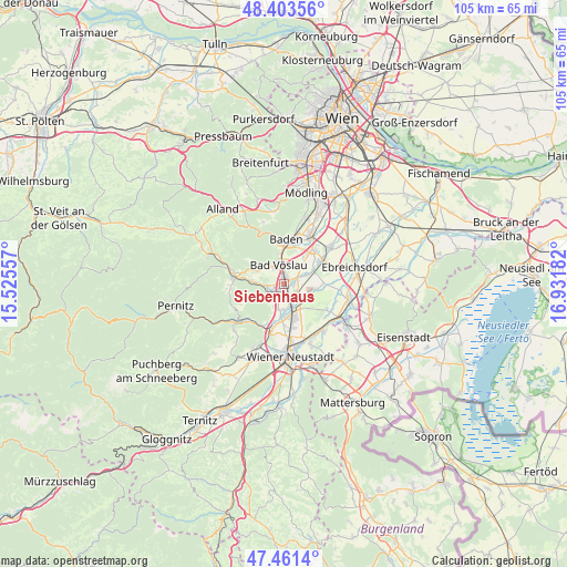
Siebenhaus GPS coordinates[2]
47° 56' 4.668" North, 16° 13' 43.284" East
| Map corner | latitude | longitude |
|---|---|---|
| Upper-left | 48.40356°, | 15.52557° |
| Center: | 47.93463°, | 16.22869° |
| Lower-right: | 47.4614°, | 16.93182° |
| Map W x H: | 104.8×104.8 km | = 65.1×65.1mi |
| max Lat: | 48.98333° ⇑37.5% North |
| Siebenhaus: | 47.93463° |
| min Lat: | ⇓62.5% South 46.48841° |
| min Long | Siebenhaus | max Long |
| 9.57802° | 16.22869° | 17.1° |
| W 86.7%⇐ | ⇒13.3% E |
Elevation
Elevation of Siebenhaus is 260 m = 853 ft, and this is 245.5 m = 805 ft below average elevation for this country.
| Max E: |
2140 m = 7021 ft | 82.8% |
| Avg. | 505.5 m = 1658 ft | |
| Siebenhaus | 260 m = 853 ft | |
Min E: |
118 m = 387 ft | 17.2% |
See also: Austria elevation on elevation.city.
Geographical zone
Siebenhaus is located in North temperate zone (between Tropic of Cancer and the Arctic Circle). Distance of this North polar circle is 2071.3 km =1287 mi to North.| Distance of | km | miles | from Siebenhaus |
|---|---|---|---|
| North Pole | 4677.2 | 2906.3 | to North |
| Arctic Circle | 2071.3 | 1287 | to North |
| Tropic Cancer | 2723.9 | 1692.6 | to South |
| Equator | 5329.8 | 3311.8 | to South |


Nearby cities:
15 places around Siebenhaus: (largest is in red/bold)
• Bad Vöslau
3.6 km =2.2 mi,  341°
341°
• Felixdorf
6 km =3.7 mi,  170°
170°
• Gainfarn
4.1 km =2.5 mi,  320°
320°
• Großau
5.1 km =3.2 mi,  297°
297°
• Günselsdorf
2.6 km =1.6 mi,  66°
66°
• Hirtenberg
3.7 km =2.3 mi,  263°
263°
• Kottingbrunn
1.8 km =1.1 mi,  356°
356°
• Leobersdorf
1.2 km =0.7 mi,  230°
230°
• Matzendorf
4.9 km =3 mi,  192°
192°
• Oeynhausen
7.3 km =4.5 mi,  39°
39°
• Schönau an der Triesting
1.9 km =1.2 mi,  90°
90°
• Sollenau
4.3 km =2.7 mi,  160°
160°
• Sooss
5.6 km =3.5 mi,  351°
351°
• Tattendorf
5.6 km =3.5 mi, 72°
• Teesdorf
4.4 km =2.7 mi, 67°
Sources, notices
• [Note1] Compared only with cities in Austria existing in our database
• [Src1] Map data: © OpenStreetMap contributors (CC-BY-SA)
• [Src2] Other city data from geonames.org with taken over terms of usage.
• [Src3] Geographical zone / Annual Mean Temperature by Robert A. Rohde @ Wikipedia
