Kottingbrunn geodata
Kottingbrunn (Lower Austria) is a seat of a third-order administrative division; located in Austria in Europe/Vienna (GMT+2) time zone. With population of 7,417 people, there are 124 cities with bigger population in this country. Compared to other cities in Austria, 63.5% of cities are located further ↓South; 86.7% of cities are located further ←West and 84% of cities have higher elevation than Kottingbrunn. Note1
Administrative division(s):
- Level 1: Lower Austria
- Level 2: Politischer Bezirk Baden
- Level 3: Kottingbrunn


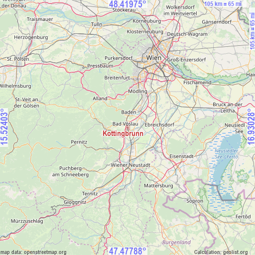
Kottingbrunn GPS coordinates[2]
47° 57' 3.456" North, 16° 13' 37.74" East
| Map corner | latitude | longitude |
|---|---|---|
| Upper-left | 48.41975°, | 15.52403° |
| Center: | 47.95096°, | 16.22715° |
| Lower-right: | 47.47788°, | 16.93028° |
| Map W x H: | 104.7×104.7 km | = 65.1×65.1mi |
| max Lat: | 48.98333° ⇑36.5% North |
| Kottingbrunn: | 47.95096° |
| min Lat: | ⇓63.5% South 46.48841° |
| min Long | Kottingbrunn | max Long |
| 9.57802° | 16.22715° | 17.1° |
| W 86.7%⇐ | ⇒13.3% E |
Elevation
Elevation of Kottingbrunn is 252 m = 827 ft, and this is 253.5 m = 832 ft below average elevation for this country.
| Max E: |
2140 m = 7021 ft | 84% |
| Avg. | 505.5 m = 1658 ft | |
| Kottingbrunn | 252 m = 827 ft | |
Min E: |
118 m = 387 ft | 16% |
See also: Austria elevation on elevation.city.
Geographical zone
Kottingbrunn is located in North temperate zone (between Tropic of Cancer and the Arctic Circle). Distance of this North polar circle is 2069.5 km =1285.9 mi to North.| Distance of | km | miles | from Kottingbrunn |
|---|---|---|---|
| North Pole | 4675.4 | 2905.2 | to North |
| Arctic Circle | 2069.5 | 1285.9 | to North |
| Tropic Cancer | 2725.7 | 1693.7 | to South |
| Equator | 5331.6 | 3312.9 | to South |


Nearby cities:
15 places around Kottingbrunn: (largest is in red/bold)
• Bad Vöslau
1.9 km =1.2 mi,  327°
327°
• Baden
6.1 km =3.8 mi,  3°
3°
• Gainfarn
2.8 km =1.7 mi,  297°
297°
• Großau
4.4 km =2.7 mi,  276°
276°
• Günselsdorf
2.6 km =1.6 mi,  107°
107°
• Hirtenberg
4.2 km =2.6 mi,  238°
238°
• Leobersdorf
2.7 km =1.7 mi,  197°
197°
• Matzendorf
6.7 km =4.2 mi,  188°
188°
• Oeynhausen
6.1 km =3.8 mi,  51°
51°
• Schönau an der Triesting
2.7 km =1.7 mi,  132°
132°
• Siebenhaus
1.8 km =1.1 mi,  176°
176°
• Sollenau
6.1 km =3.8 mi,  164°
164°
• Sooss
3.8 km =2.4 mi,  348°
348°
• Tattendorf
5.4 km =3.4 mi,  91°
91°
• Teesdorf
4.2 km =2.6 mi, 91°
Sources, notices
• [Note1] Compared only with cities in Austria existing in our database
• [Src1] Map data: © OpenStreetMap contributors (CC-BY-SA)
• [Src2] Other city data from geonames.org with taken over terms of usage.
• [Src3] Geographical zone / Annual Mean Temperature by Robert A. Rohde @ Wikipedia
