Kaindorf geodata
Kaindorf (Styria) is a seat of a third-order administrative division; located in Austria in Europe/Vienna (GMT+2) time zone. With population of 1,149 people, there are 1101 cities with bigger population in this country. Compared to other cities in Austria, 70.6% of cities are located further ↑North; 77.7% of cities are located further ←West and 68.1% of cities have higher elevation than Kaindorf. Note1
Administrative division(s):
- Level 1: Styria
- Level 2: Politischer Bezirk Hartberg-Fürstenfeld
- Level 3: Kaindorf


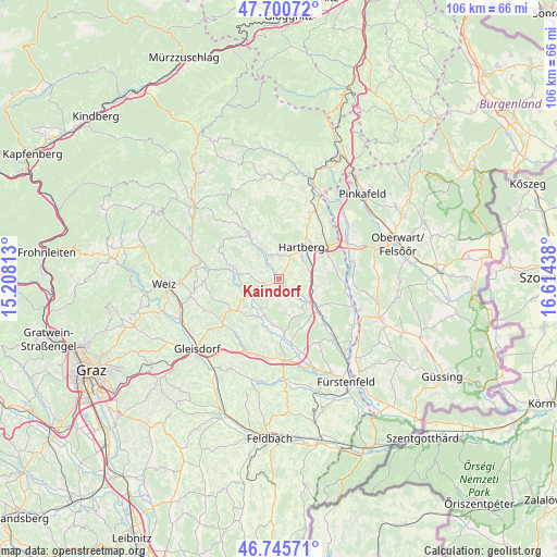
Kaindorf GPS coordinates[2]
47° 13' 31.332" North, 15° 54' 40.5" East
| Map corner | latitude | longitude |
|---|---|---|
| Upper-left | 47.70072°, | 15.20813° |
| Center: | 47.22537°, | 15.91125° |
| Lower-right: | 46.74571°, | 16.61438° |
| Map W x H: | 106.2×106.2 km | = 66×66mi |
| max Lat: | 48.98333° ⇑70.6% North |
| Kaindorf: | 47.22537° |
| min Lat: | ⇓29.4% South 46.48841° |
| min Long | Kaindorf | max Long |
| 9.57802° | 15.91125° | 17.1° |
| W 77.7%⇐ | ⇒22.3% E |
Elevation
Elevation of Kaindorf is 338 m = 1109 ft, and this is 167.5 m = 550 ft below average elevation for this country.
| Max E: |
2140 m = 7021 ft | 68.1% |
| Avg. | 505.5 m = 1658 ft | |
| Kaindorf | 338 m = 1109 ft | |
Min E: |
118 m = 387 ft | 31.9% |
See also: Austria elevation on elevation.city.
Geographical zone
Kaindorf is located in North temperate zone (between Tropic of Cancer and the Arctic Circle). Distance of this North polar circle is 2150.2 km =1336.1 mi to North.| Distance of | km | miles | from Kaindorf |
|---|---|---|---|
| North Pole | 4756.1 | 2955.3 | to North |
| Arctic Circle | 2150.2 | 1336.1 | to North |
| Tropic Cancer | 2645 | 1643.5 | to South |
| Equator | 5251 | 3262.8 | to South |


Nearby cities:
15 places around Kaindorf: (largest is in red/bold)
• Blaindorf
6.5 km =4 mi,  210°
210°
• Dienersdorf
1.8 km =1.1 mi,  335°
335°
• Ebersdorf
4.9 km =3 mi,  127°
127°
• Flattendorf
4.6 km =2.9 mi,  5°
5°
• Grosshart
7.2 km =4.5 mi,  155°
155°
• Hartberg
7.7 km =4.8 mi,  32°
32°
• Hartl
4.7 km =2.9 mi,  174°
174°
• Hirnsdorf
7.3 km =4.5 mi,  239°
239°
• Hofkirchen
2.6 km =1.6 mi,  327°
327°
• Kaibing
6.5 km =4 mi, 244°
• Löffelbach
6.7 km =4.2 mi, 14°
• Ring
7.9 km =4.9 mi, 30°
• Safenau
7.1 km =4.4 mi,  49°
49°
• Sebersdorf
7.6 km =4.7 mi,  124°
124°
• Unterbuch
6 km =3.7 mi,  87°
87°
Sources, notices
• [Note1] Compared only with cities in Austria existing in our database
• [Src1] Map data: © OpenStreetMap contributors (CC-BY-SA)
• [Src2] Other city data from geonames.org with taken over terms of usage.
• [Src3] Geographical zone / Annual Mean Temperature by Robert A. Rohde @ Wikipedia
