Schwaz geodata
Schwaz (Tyrol) is a seat of a second-order administrative division; located in Austria in Europe/Vienna (GMT+2) time zone. With population of 13,728 people, there are 51 cities with bigger population in this country. Compared to other cities in Austria, 62.3% of cities are located further ↑North; 90.4% of cities are located further →East and 62.7% of cities have lower elevation than Schwaz. Note1


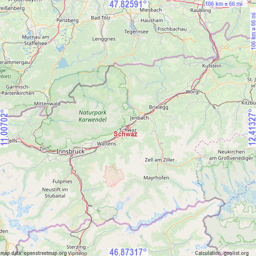
Schwaz GPS coordinates[2]
47° 21' 6.084" North, 11° 42' 36.504" East
| Map corner | latitude | longitude |
|---|---|---|
| Upper-left | 47.82591°, | 11.00702° |
| Center: | 47.35169°, | 11.71014° |
| Lower-right: | 46.87317°, | 12.41327° |
| Map W x H: | 105.9×105.9 km | = 65.8×65.8mi |
| max Lat: | 48.98333° ⇑62.3% North |
| Schwaz: | 47.35169° |
| min Lat: | ⇓37.7% South 46.48841° |
| min Long | Schwaz | max Long |
| 9.57802° | 11.71014° | 17.1° |
| W 9.6%⇐ | ⇒90.4% E |
Elevation
Elevation of Schwaz is 537 m = 1762 ft, and this is 31.5 m = 103 ft above average elevation for this country.
| Max E: |
2140 m = 7021 ft | 37.3% |
| Schwaz | 537 m 1762 ft | |
| Avg. | 505.5 m = 1658 ft | |
Min E: |
118 m = 387 ft | 62.7% |
See also: Austria elevation on elevation.city.
Geographical zone
Schwaz is located in North temperate zone (between Tropic of Cancer and the Arctic Circle). Distance of this North polar circle is 2136.2 km =1327.4 mi to North.| Distance of | km | miles | from Schwaz |
|---|---|---|---|
| North Pole | 4742 | 2946.5 | to North |
| Arctic Circle | 2136.2 | 1327.4 | to North |
| Tropic Cancer | 2659.1 | 1652.3 | to South |
| Equator | 5265 | 3271.5 | to South |


Nearby cities:
15 places around Schwaz: (largest is in red/bold)
• Buch in Tirol
4.2 km =2.6 mi,  52°
52°
• Eben am Achensee
7.9 km =4.9 mi,  29°
29°
• Fiecht
0.8 km =0.5 mi,  256°
256°
• Gallzein
5 km =3.1 mi,  68°
68°
• Jenbach
6.5 km =4 mi, 46°
• Kolsass
8.2 km =5.1 mi,  225°
225°
• Maurach
8.4 km =5.2 mi,  22°
22°
• Neu-Terfens
6.9 km =4.3 mi, 234°
• Pill
3.9 km =2.4 mi,  215°
215°
• Stans
1.7 km =1.1 mi, 16°
• Terfens
5.9 km =3.7 mi,  237°
237°
• Vomp
2.9 km =1.8 mi, 224°
• Vomperbach
3.9 km =2.4 mi, 238°
• Weer
7.2 km =4.5 mi, 222°
• Weerberg
6.8 km =4.2 mi,  209°
209°
Sources, notices
• [Note1] Compared only with cities in Austria existing in our database
• [Src1] Map data: © OpenStreetMap contributors (CC-BY-SA)
• [Src2] Other city data from geonames.org with taken over terms of usage.
• [Src3] Geographical zone / Annual Mean Temperature by Robert A. Rohde @ Wikipedia
